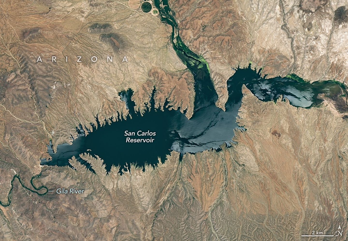
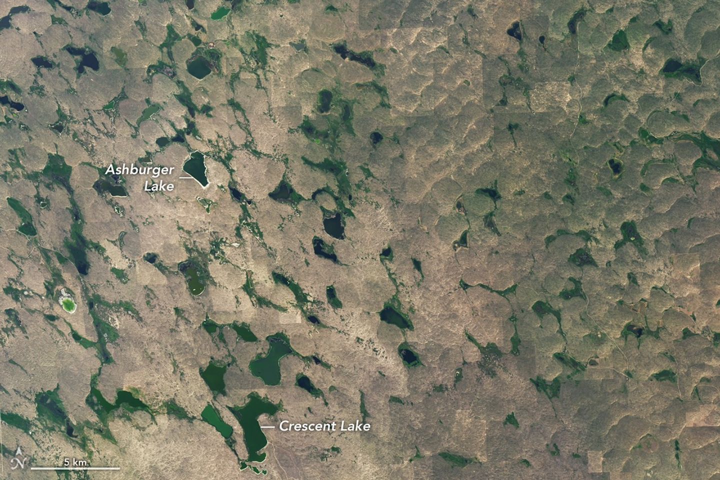
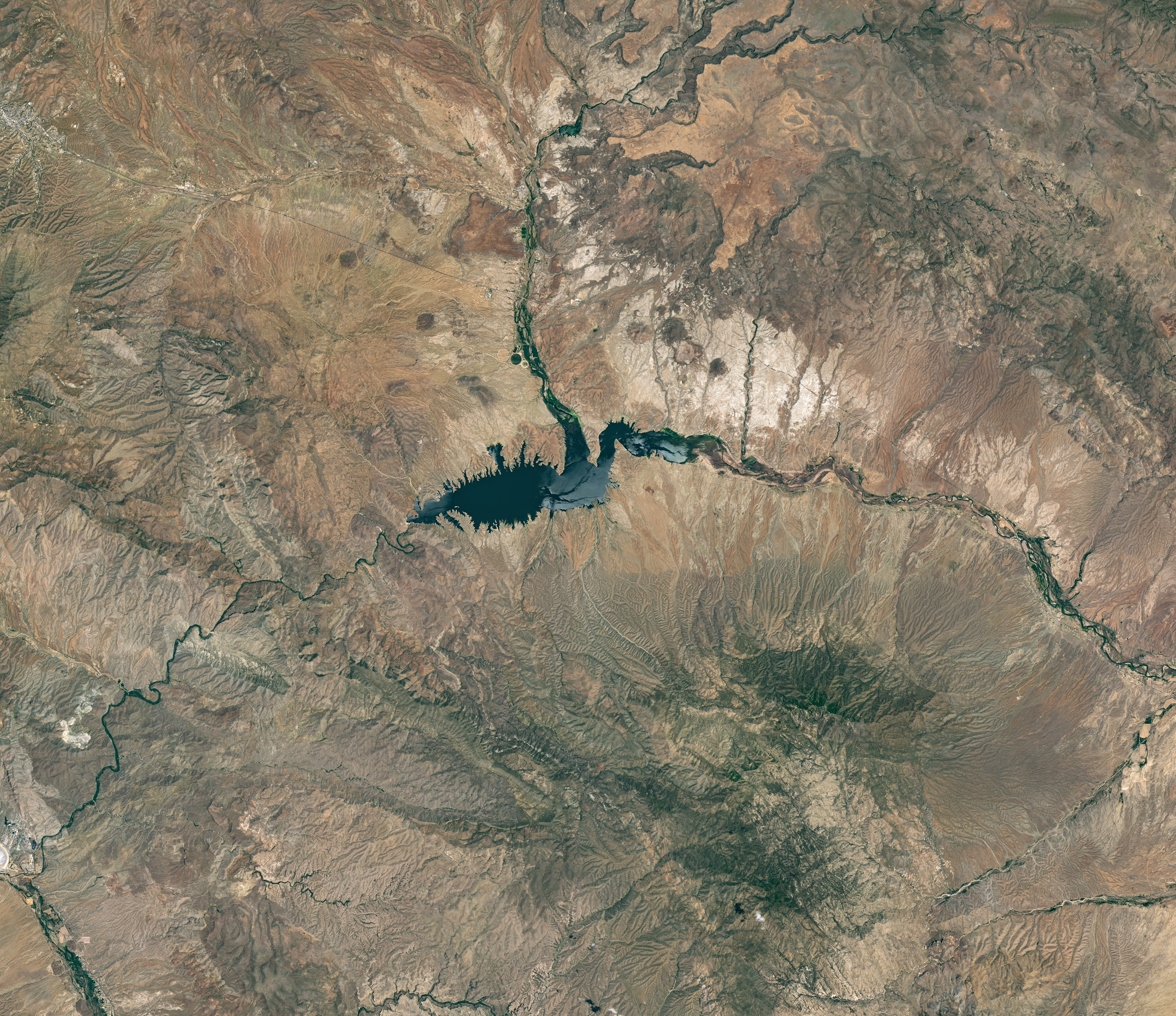
Low Water at San Carlos Reservoir
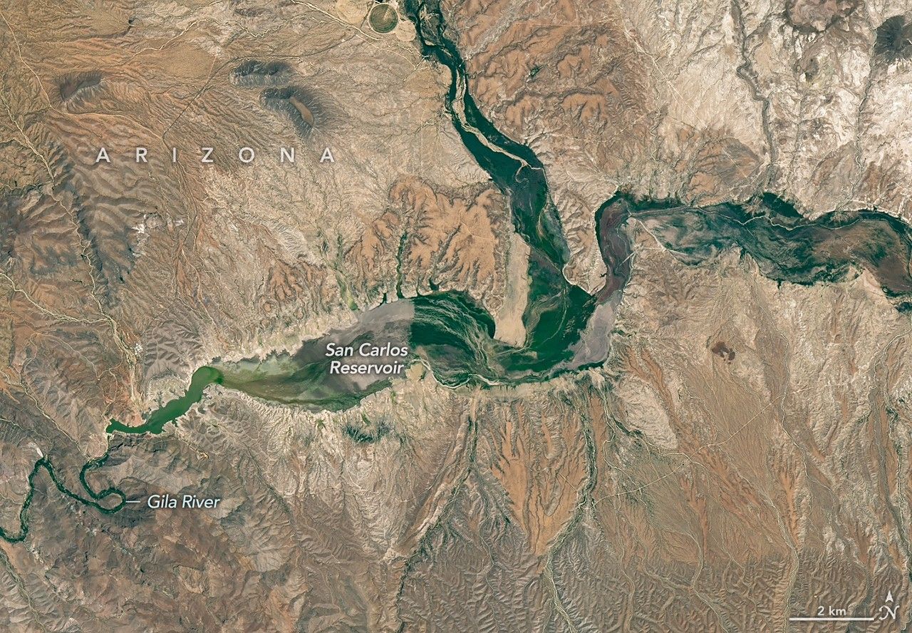


June 7, 2023
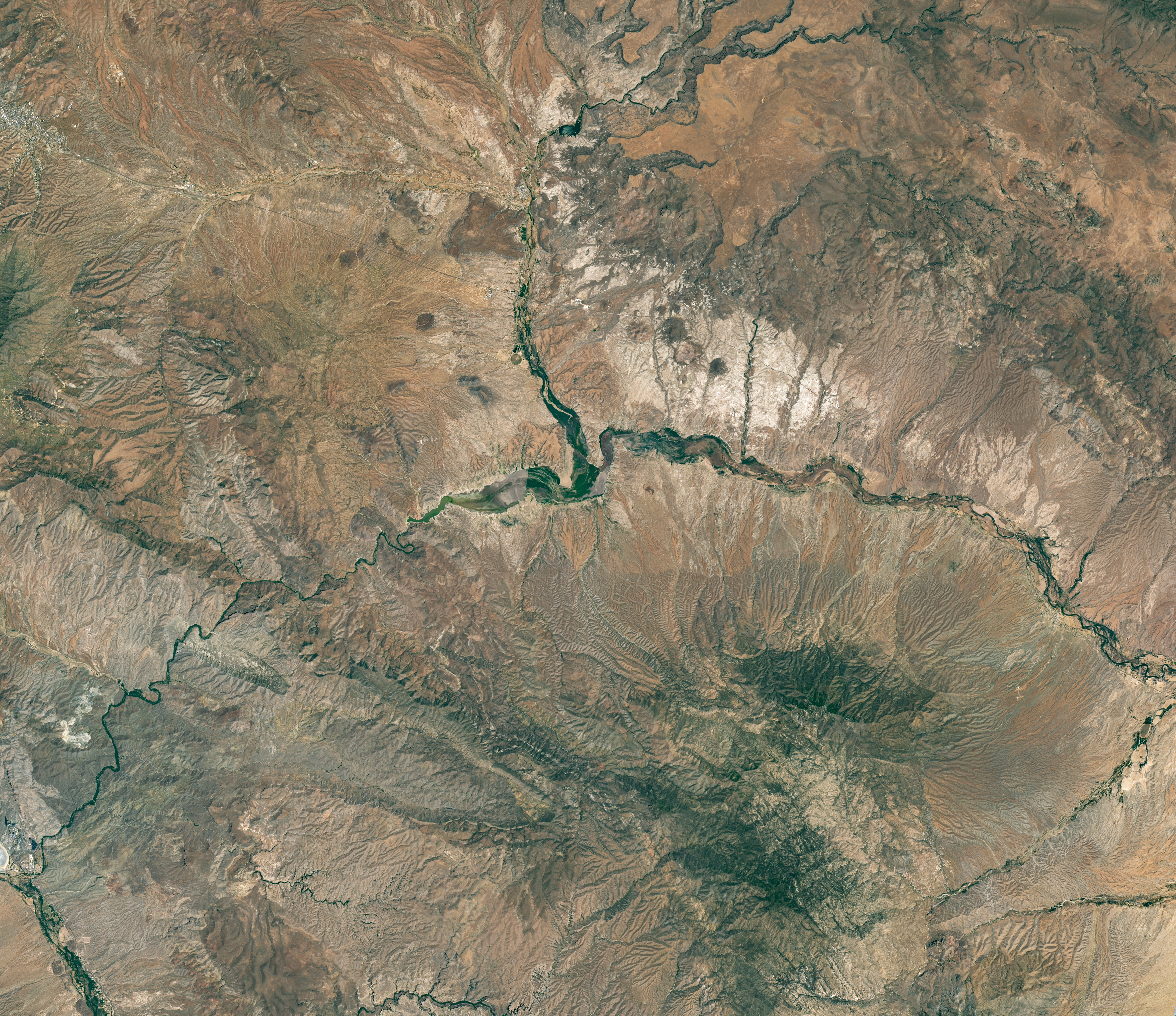
May 22, 2026
The Gila River is among the Southwest’s most important rivers, delivering water for people, farms, and wildlife while linking the snow-fed mountains of southwestern New Mexico to the desert lowlands of southwestern Arizona.
In wetter years, seasonal snowfall on the Mogollon Mountains and Black Range provides much of the river’s spring flow and helps refill San Carlos Reservoir, which is formed by the Coolidge Dam. When filled to capacity, the reservoir is one of Arizona’s largest bodies of water.
However, in 2026, lackluster snowfall left the mountain snowpack in the Gila River watershed at 2 percent of the 1991-2020 March median. The limited snowpack pushed April streamflow to 39 percent of normal. By June, after mandatory water releases for downstream agriculture, the reservoir held less than 400 acre-feet of water.
The Landsat image above (right) shows the near-empty reservoir on May 22, 2026, when it stored 389 acre-feet of water—less than 1 percent full; the other image (left) shows the same area in June 2023, when it was about 60 percent full. The green vegetation growing along the river channel and reservoir edge includes a mixture of tamarisk, willow, cottonwood, sedges, and grasses.
Officials closed the reservoir indefinitely on June 5, 2026, after the declining water levels contributed to low oxygen levels—hypoxia—that killed virtually all of its fish. Species living in the reservoir included largemouth bass, black crappie, bluegill, channel catfish, flathead catfish, and several stocked species, including brown trout and rainbow trout. The decomposing fish may pose health risks to people attempting to boat or fish, the San Carlos Recreation and Wildlife Department warned.
The reservoir has hit similarly low water levels in the past, running out of water at least 20 times since it was filled in 1930, according to news reports. Even when the dam and reservoir were first dedicated, there was enough grass growing on the dried reservoir bottom that humorist Will Rogers famously quipped to President Calvin Coolidge: “If that was my lake, I’d mow it.”
Other years with major fish kills include 1976 and 2018. After more than 5 million fish died during a similar event in 1976, the Gila Herald reported that it took five years for the lake’s ecosystem to rebound.
The region is currently in the midst of a multi-year dry period that has left much of the Gila River’s headwaters in New Mexico in a state of severe drought, according to data from the U.S. Drought Monitor.
However, the river’s flow is highly variable, and heavy rains during the coming wet season could help the reservoir recover. A seasonal monsoon outlook released by NOAA in May 2026 projected a 33 to 50 percent chance that an above-average amount of rain would fall in the region that summer. El Niño in the central and eastern equatorial Pacific, which was strengthening in late spring 2026, can make heavy rains in the U.S. Southwest more likely.
NASA Earth Observatory images by Michala Garrison, using Landsat data from the U.S. Geological Survey. Story by Adam Voiland.

References & Resources
- Arizona Silver Belt (2026, April 23) Low water levels prompt lifted fishing limits at San Carlos Lake. Accessed June 16, 2026.
- Calvin Coolidge Presidential Foundation (2015, March 4) 85 Years of the Coolidge Dam! Accessed June 16, 2026.
- Gila Herald (2026, June 7) San Carlos Lake Closed Indefinitely Following Catastrophic “100% Fish Kill.” Accessed June 16, 2026.
- Natural Resources Conservation Service (2026, April 1) New Mexico Water Supply Outlook Report. Accessed June 16, 2026.
- National Weather Service (2026, May 21) 2026 Arizona Monsoon Outlook. Accessed June 16, 2026.
- National Integrated Drought Information System (2026, June 9) Lower Colorado Region Watershed Drought Information. Accessed June 16, 2026.
- National Weather Service (2026, May 4) Drought Information Statement for Southern NM/Far West TX. Accessed June 16, 2026.
- Pinal Central (2026, June 6) San Carlos Reservoir level very low, but not unprecedented. Accessed June 16, 2026.
- San Carlos Recreation and Wildlife Department (2026, June 5) San Carlos Lake Closure. Accessed June 16, 2026.
- True West (2016, February 1) Will Rogers in Arizona. Accessed June 16, 2026.
- The University of Arizona (2026, May 28) Southwest Climate Outlook. Accessed June 16, 2026.
- U.S. Geological Survey (2026, June 15) San Carlos Reservoir at Coolidge Dam, AZ. Accessed June 16, 2026.
- USA Today (2026, June 9) Massive fish kill forces indefinite closure of Arizona lake. Accessed June 16, 2026.
- Western-Water (2026, June 8) San Carlos Reservoir: Drought kills every fish. Accessed June 16, 2026.
You may also be interested in:
Stay up-to-date with the latest content from NASA as we explore the universe and discover more about our home planet.

The state was unusually dry for much of 2025, but the intensity of the drought has ratcheted up since January…

The mountains of Utah and Colorado are among the areas of the western U.S. that are low on snow and…

Above-normal precipitation has swollen rivers and damaged infrastructure statewide.
Discover More from NASA Earth Science
Subscribe to Earth Observatory Newsletters
Subscribe to the Earth Observatory and get the Earth in your inbox.
Earth Observatory Image of the Day
NASA’s Earth Observatory brings you the Earth, every day, with in-depth stories and stunning imagery.

Explore Earth Science

Earth Science Data
Open access to NASA’s archive of Earth science data


