Vista elenco

Nebraska’s Wide, Rolling Domain

16 Giugno 2026 ore 06:01
The landscape in northwestern Nebraska has a rippled appearance, with tan parallel ridges running from left to right and green areas and small lakes filling the low-lying spaces in between.
The Nebraska Sandhills stretch across the north-central part of the state in this image acquired on August 19, 2025, with the OLI (Operational Land Imager) on Landsat 8.
NASA Earth Observatory/Lauren Dauphin

Editor’s Note: Today’s story is the answer to the June Puzzler.

The undulating landscape of north-central Nebraska may be easy to overlook among the iconic dune fields of the world. Far from any coast or desert, the Nebraska Sandhills—comprising the Western Hemisphere’s largest system of sand dunes—bring their own brand of beauty and value. Grasslands blanket the rolling hills, providing grazing grounds for livestock, while lakes and wetlands dot the landscape, supporting diverse plant and animal life.

Much of the sand forming the hills originated in the Rocky Mountains. Rivers carried the eroded material down from the mountains and deposited it across the Great Plains during the Pleistocene. In times of drought, winds blowing predominantly from the north or south lofted sand out of dried riverbeds, gradually building and shaping dunes. About 3,500 years ago, grassland vegetation stabilized the features. Today, the rippled pattern spans about 20,000 square miles (52,000 square kilometers), about one-quarter of the state of Nebraska.

A series of tan parallel ridges runs from left to right, with green areas and small lakes filling the low-lying spaces in between.
Some of the largest, grassland-covered dunes in the Nebraska Sandhills are found in the northwestern part of the region, shown in this image acquired on August 19, 2025, with the OLI (Operational Land Imager) on Landsat 8.
NASA Earth Observatory/Lauren Dauphin

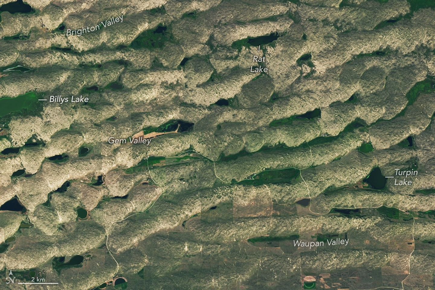
Some of the largest dunes occur in and around the area shown in the detailed image above, near the northern edge of the Sandhills region. These transverse dunes stand as high as 400 feet (120 meters) and extend for several miles. Their northern slopes are gentler than their southern slopes, reflecting the dominant influence of northerly winds. In other areas, dunes are more symmetric, suggesting that winds blew with nearly equal strength from the north and south, alternating with the seasons.  

The grasslands that now cover the hills constitute pastureland for grazing livestock. Ranching expanded significantly in the area after passage of the Kinkaid Act in 1904, which allotted 640-acre parcels of land to ranchers who would settle it. Today, far more cattle than humans occupy the region, and half of Nebraska’s nearly 23 million acres of rangeland and pastureland are in the Sandhills. Some ranchers graze their cattle in patterns meant to approximate the large bison herds that once roamed the land.

Small, irregularly shaped lakes and marshy areas are interspersed among tan hills.
Lakes and wetlands fill the valleys between dunes in Crescent Lake National Wildlife Refuge, shown in this image acquired on August 19, 2025, with the OLI (Operational Land Imager) on Landsat 8.
NASA Earth Observatory/Lauren Dauphin

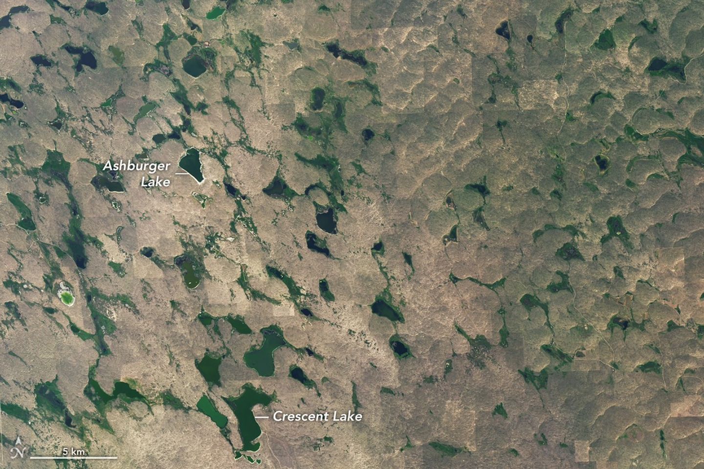
Though much of the land in the Sandhills is privately owned, some is set aside in protected public lands. One of these areas, Crescent Lake National Wildlife Refuge on the southwestern edge of the Sandhills region, is shown above. Wetlands, including shallow lakes, marshes, and wet meadows, fill some of the valleys between the dunes. The land here is sponge-like, with precipitation seeping down through the soil and recharging groundwater instead of flowing off through stream channels.

Located along the Central Flyway, the refuge is a haven for migratory birds, and dozens of species of waterfowl, marsh birds, and shorebirds utilize the area. Among other wildlife, several types of turtles thrive in the ponds and prairies. Wetlands across the Sandhills support rare species such as the whooping crane, western prairie fringed orchid, and Topeka shiner.

NASA Earth Observatory images by Lauren Dauphin, using Landsat data from the U.S. Geological Survey. Story by Lindsey Doermann.

Downloads

The landscape in northwestern Nebraska has a rippled appearance, with tan parallel ridges running from left to right and green areas and small lakes filling the low-lying spaces in between.

August 19, 2025

JPEG (10.71 MB)

References & Resources

You may also be interested in:

Stay up-to-date with the latest content from NASA as we explore the universe and discover more about our home planet.

Fires Tear Through Nebraska Grasslands

3 min read

Dry, warm, and windy conditions across the U.S. Great Plains led to extreme fire activity in March 2026.

Article

Farming in Ancient Lake Agassiz

3 min read

The glacial lake left a layer of silt and clay in southeastern Manitoba, creating fertile farmland that was divided during…

Article

America’s Emerald Isle

3 min read

Beaver Island is one in a string of verdant and scenic jewels in a northern Lake Michigan archipelago.

Article

Tyndall’s Trail of Bergs

10 Giugno 2026 ore 06:01
A top-down photo shows a glacier running from north to south amid snowy, mountainous terrain. The glacier flows into a narrow lake where many small icebergs are visible floating on the water.
May 10, 2026

The Southern Patagonian Icefield is the largest expanse of ice in the Southern Hemisphere outside of Antarctica. The mass of glacial ice extends hundreds of kilometers along the spine of the Andes, feeding dozens of dynamic outlet glaciers that grind their way down from higher elevations. Many of these rivers of ice terminate in the sea or in proglacial lakes.

An astronaut aboard the International Space Station photographed one of these glaciers—Tyndall Glacier in southern Chile—through a layer of ethereal clouds on May 10, 2026. Fragments of ice that had calved off its terminus were visible floating on Lago Geikie.

Like most Patagonian glaciers, Tyndall has been shrinking since the end of the Little Ice Age about 150 years ago. Lago Geikie formed at Tyndall’s terminus around 1940, according to glaciologist Mauri Pelto of Nichols College, and gradually expanded as the ice retreated. Part of the glacier previously terminated in Lago Tyndall to the east, but thinning ice cut off that outlet by 2010, Pelto said. (The ice’s retreat also exposed bedrock along its eastern edge that contains scores of ichthyosaur fossils.)

Along with thinning, ice calving off the glacier’s front has reduced its volume. Tyndall has lost 2.2 kilometers (1.4 miles) in length since November 2022, Pelto said, following about a decade of limited retreat with considerable thinning. A significant calving event in March and April 2023 contributed to the recent uptick in ice retreat. During that time, satellites observed several large icebergs breaking away from Tyndall’s terminus.

Austral autumn in 2026 was a time of active calving retreat at Tyndall (and some neighboring glaciers), Pelto said, albeit more incremental than three years prior. “The substantial crevasses crisscrossing the glacier near the calving front lead to many smaller icebergs,” he said. On the other hand, larger tabular icebergs tend to form when there are fewer deep crevasses near the terminus and the glacier’s ice is thinner.

A top-down photo shows a detailed view of the leading edge of a glacier terminating in a lake. The glacial ice is heavily crevassed with intersecting linear features.
May 10, 2026

The ice cliff at the terminus casts a substantial shadow, which can help scientists estimate the height of the glacier’s front. Pelto’s calculations, using information about the Sun’s position provided with the image, indicate that Tyndall’s front loomed 30–40 meters (100–130 feet) above the lake surface in May 2026. Observations from orbit, including astronaut photographs, can help scientists monitor and understand glaciers in remote regions where ground-based observations are scarce.

As for what comes next for Tyndall, Pelto expects many more small icebergs to continue breaking off, given the heavily crevassed appearance of the calving front. “Look for a burst of iceberg production next fall.”

Astronaut photograph ISS074-E-582898 was acquired on May 10, 2026, with a Nikon Z9 digital camera using a focal length of 560 millimeters. It is provided by the ISS Crew Earth Observations Facility and the Earth Science and Remote Sensing Unit at NASA Johnson Space Center. The image was taken by a member of the Expedition 74 crew. The image has been cropped and enhanced to improve contrast, and lens artifacts have been removed. The International Space Station Program supports the laboratory as part of the ISS National Lab to help astronauts take pictures of Earth that will be of the greatest value to scientists and the public, and to make those images freely available on the Internet. Additional images taken by astronauts and cosmonauts can be viewed at the NASA/JSC Gateway to Astronaut Photography of Earth. Story by Lindsey Doermann.

Downloads

A top-down photo shows a glacier running from north to south amid snowy, mountainous terrain. The glacier flows into a narrow lake where many small icebergs are visible floating on the water.

May 10, 2026 (wide)

JPEG (11.19 MB)

A top-down photo shows a detailed view of the leading edge of a glacier terminating in a lake. The glacial ice is heavily crevassed with intersecting linear features.

May 10, 2026 (detailed)

JPEG (3.43 MB)

References & Resources

You may also be interested in:

Stay up-to-date with the latest content from NASA as we explore the universe and discover more about our home planet.

Record-Setting Retreat of Hektoria Glacier

5 min read

Scientists relied on satellite data to understand how the Antarctic glacier lost so much ice so rapidly.

Article

Stonebreen’s Beating Heart

3 min read

The glacier in southeastern Svalbard pulses with the changing seasons, speeding up and slowing its flow toward the sea.

Article

Cañon Fiord’s Whirling Waters

3 min read

During the 2022 summer melt season, sediment plumes and fractured sea ice traced swirling eddies in a branch of the…

Article

San Francisco’s Metropolitan Mosaic

9 Giugno 2026 ore 06:00
A top-down photo of San Francisco shows dense gray urban infrastructure interspersed with green parks. Waves and ships are visible in the surrounding blue-green water.
May 27, 2026

A period of unsettled weather brought scattered showers and thunderstorms to California’s Bay Area on May 27, 2026. That afternoon, a break in the clouds left downtown San Francisco and nearby communities beneath mostly cloud-free skies, allowing an astronaut aboard the International Space Station to take this photograph.

The image captures two of the region’s iconic bridges. The Golden Gate Bridge connects the northern San Francisco Peninsula with Marin County to the north, while the San Francisco-Oakland Bay Bridge spans the bay toward Oakland to the east.  

Near the center of the image, Golden Gate Park stands out as a long, rectangular strip of green amid the dense urban landscape. Spanning more than 1,000 acres (400 hectares), the park encompasses meadows, gardens, wooded areas, and lakes. Additional green space toward the north around the Golden Gate Bridge is part of a national recreation area

The nadir (downward-looking) perspective also provides a clear view of the patchwork of street grids, which were laid out over San Francisco’s hilly terrain as the city grew in successive stages. In the heart of the downtown area, Market Street runs southwest to northeast and serves as a prominent divider between two distinct grid orientations: one aligned with the bay and the other aligned with the street.  

Along the northeastern and eastern waterfront, various structures extend into the bay. Toward the north, these include a historic wharf, seawalls, and piers—most built in the early 1900s, though some date back into the 1800s. The adjacent waters support heavy maritime traffic, including cargo and container ships, cruise vessels, and regional ferries.

Breaking waves are visible along the western coast, including at Ocean Beach, the 3.5-mile stretch of sandy shore adjacent to Golden Gate Park. On May 27, the National Weather Service warned of hazardous conditions at the region’s beaches due to strong northerly winds. Long-period swells from the northwest contributed to the increased risk of rip currents as well as sneaker waves in the days after this image was acquired.

Astronaut photograph ISS074-E-619284 was acquired on May 27, 2026, with a Nikon Z9 digital camera using a focal length of 800 millimeters. It is provided by the ISS Crew Earth Observations Facility and the Earth Science and Remote Sensing Unit at NASA Johnson Space Center. The image was taken by a member of the Expedition 74 crew. The image has been cropped and enhanced to improve contrast, and lens artifacts have been removed. The International Space Station Program supports the laboratory as part of the ISS National Lab to help astronauts take pictures of Earth that will be of the greatest value to scientists and the public, and to make those images freely available on the Internet. Additional images taken by astronauts and cosmonauts can be viewed at the NASA/JSC Gateway to Astronaut Photography of Earth. Story by Kathryn Hansen.

Downloads

A top-down photo of San Francisco shows dense gray urban infrastructure interspersed with green parks. Waves and ships are visible in the surrounding blue-green water.

May 27, 2026

JPEG (12.13 MB)

References & Resources

You may also be interested in:

Stay up-to-date with the latest content from NASA as we explore the universe and discover more about our home planet.

Belts of Green in the Washington Suburbs

3 min read

Along the northeast side of the Capital Beltway in Maryland, green spaces weave through the developed landscape.

Article

Contours of the James Bay Lowlands

3 min read

After the Laurentide Ice Sheet retreated from present-day Hudson Bay, rebounding land has revealed striking nearshore topography.

Article

Great Balls of Fire

4 min read

An astronaut on the International Space Station was surprised to photograph a shower of light streaking through the darkness while…

Article
❌