❌

Vista elenco

NASA Names Stephen Cash Marshall Space Flight Center Director

16 Ottobre 2026 ore 22:14
Stephen Cash
Photo of Stephen Cash

NASA Administrator Jared Isaacman has named Stephen Cash director of the agency’s Marshall Space Flight Center in Huntsville, Alabama, effective Monday, Oct. 19. Cash, a veteran NASA engineer and aerospace executive, returns to lead the center where he began his career more than four decades ago.

“Marshall contributions to NASA’s missions are historic and it’s no question why it’s the Center of Excellence for propulsion,” said Isaacman. “Steve Cash is a Marshall legend, has spent his career around the hardware, the people and has been in the seat before making the decisions when human spaceflight is on the line. As Marshall continues its critical role in Artemis and takes on new challenges in advanced propulsion, nuclear power, and the systems that will carry us deeper into the solar system, Steve brings the experience, technical judgment, and mission focus needed to lead the center into that next chapter. I am also grateful to Rae Ann Meyer for the leadership she has provided to Marshall during this transition and for her continued service to NASA.” 

“Leading a NASA center requires a commitment to its people and to the technical capabilities entrusted to them,” said Amit Kshatriya, NASA associate administrator and chief engineer. “Steve understands that the jewel of Marshall is its workforce and that engineering excellence is sustained by giving talented people the opportunity to design, build, test, and learn through hands-on work. As Marshall continues strengthening the manufacturing, structural loads and dynamics, and propulsion capabilities that underpin NASA’s exploration enterprise, Steve’s leadership will help ensure the workforce has opportunities to develop and apply the expertise needed to deliver the agency’s most ambitious missions.”

 As center director, Cash will lead one of NASA’s largest field centers, overseeing a workforce of more than 5,000 civil service and contractor employees and a broad portfolio of propulsion, space systems, scientific research, and technology development activities.  Marshall plays a critical role in NASA’s Artemis program, including the development of NASA’s SLS (Space Launch System) rocket, management of the Human Landing System Program, as well as other capabilities supporting sustained exploration of the Moon and future missions to Mars. Further, Marshall plays a key role in the advancement of nuclear power and propulsion, an area of focus that is expected to grow as NASA works towards sending the first humans to Mars.  

“It is a profound honor to be back home at the Marshall Space Flight Center,” said Cash. “I am humbled to stand alongside the brilliant minds here as we continue to turn the impossible into everyday history.”

Cash began his NASA career at Marshall in 1982 and spent 34 years with the agency, holding senior engineering and management positions supporting some of the nation’s most significant human spaceflight programs.

During his NASA career, Cash served as manager of Marshall’s Space Shuttle Propulsion Office, overseeing critical propulsion systems supporting shuttle through its final missions. He later served as director of Marshall’s Safety and Mission Assurance Directorate from 2011 until his retirement in 2016, providing leadership in safety, reliability, and quality engineering to support mission success across the center.

Following his retirement from NASA, Cash continued his work in the aerospace industry, including serving as vice president for advanced space systems at Axient, supporting the development and execution of major spaceflight programs. In 2024, he was inducted into the Alabama Engineering Hall of Fame in recognition of his contributions to engineering and the nation’s space program.

Cash succeeds Rae Ann Meyer, who has served as Marshall’s acting center director since September 2025. Meyer, who previously served as Marshall’s deputy center director and associate director, has provided leadership and continuity across the center’s programs and operations during her tenure as acting director. Meyer will return to her role as Deputy Center Director.

Established in 1960, Marshall has played a central role in American space exploration for more than six decades, from developing the Saturn rockets that carried astronauts to the Moon during Apollo to advancing the propulsion systems, infrastructure, and technologies supporting the next era of human spaceflight.

For more information about NASA’s Marshall Space Flight Center, visit:

https://www.nasa.gov/marshall

-end-

George Alderman / Cheryl Warner
Headquarters, Washington
202-358-1600
george.a.alderman@nasa.gov / cheryl.m.warner@nasa.gov

Lance Davis
Marshall Space Flight Center, Huntsville, Ala.
256-544-0034
lance.d.davis@nasa.gov

Share

Details

Last Updated
Oct 16, 2026

Artemis II Heat Shield After Splashdown

16 Ottobre 2026 ore 18:28
The Orion spacecraft's heat shield dominates this underwater photo. Due to the water, the heat shield appears to be teal-colored.
US Navy

Shortly after NASA’s Artemis II mission splashed down on April 10, 2026, U.S. Navy divers captured underwater imagery of the Orion spacecraft’s heat shield. In the months after, the agency measured whether the thermal protection system effectively safeguarded the crew and Orion systems as the spacecraft reentered Earth’s atmosphere. This rigorous analysis confirmed that the heat shield performed as expected.

Learn how Orion’s heat shield was examined.

Image credit: US Navy

I Am Artemis: Allison Mjoen

16 Ottobre 2026 ore 16:24
3 Min Read

I Am Artemis: Allison Mjoen

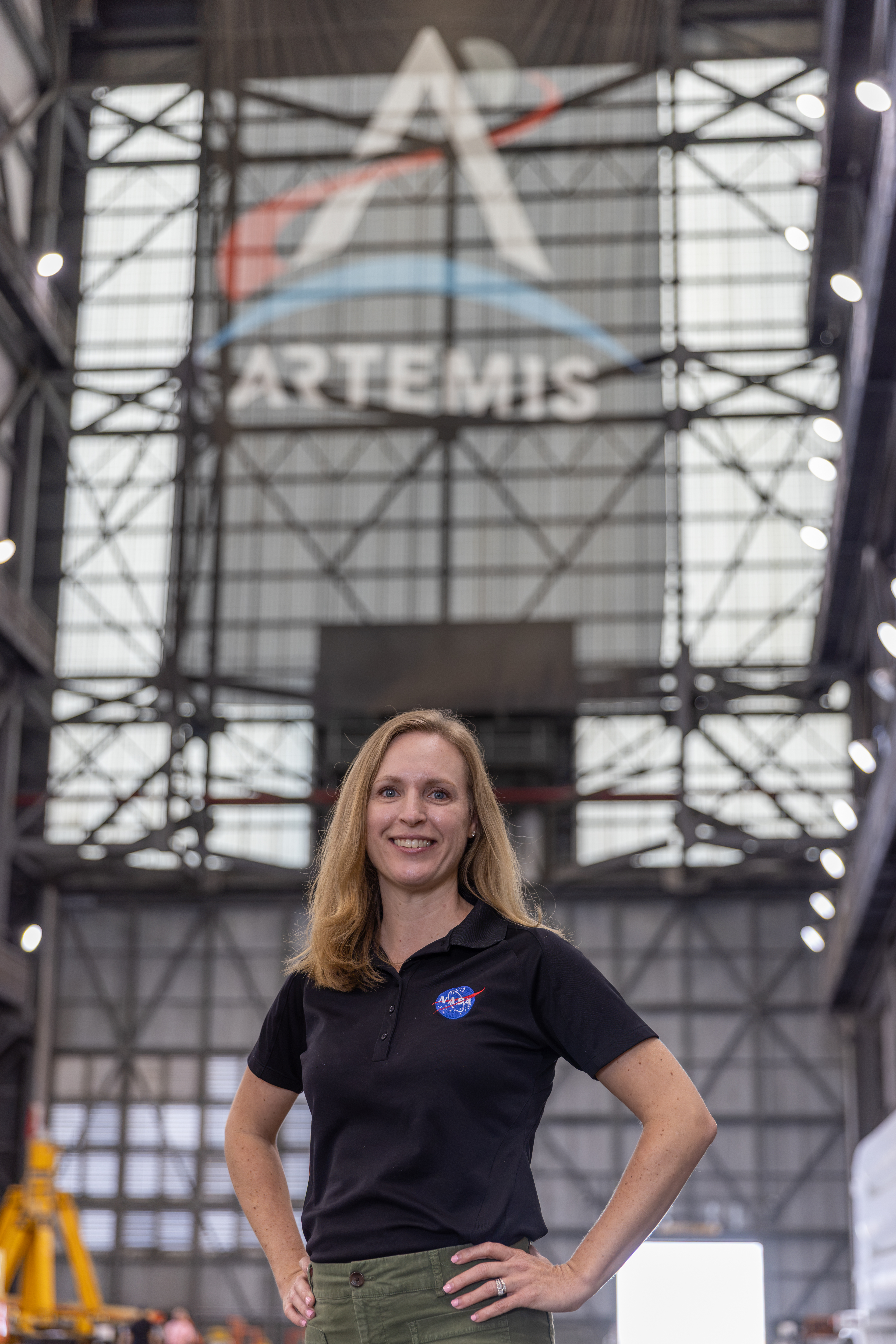
Portrait of Allison Mjoen inside the Vehicle Assembly Building

As the supercooled propellant flowed into the core stage, and NASA’s SLS (Space Launch System) rocket roared to life, Allison Mjoen and her family watched with awe and pride. Mjoen, NASA’s operations manager for the agency’s Exploration Ground Systems Program, helped shape the systems and ground operations that will one day send humans back to the Moon. Over her 20-year career at NASA’s Kennedy Space Center in Florida, she supported missions across the Space Shuttle Program, the International Space Station, and now she is applying that experience to Artemis.

April 1, 2026, was a bright, crystal-clear day along the Florida Space Coast. The sunlight seemed to sharpen every color along the horizon. As Mjoen and her children counted down and the crowd’s voices rose around them, the rumble of the SLS rocket intensified beneath their feet. For her children, it was the chance to see what their mom had helped make possible. For Mjoen, it was a moment she would never forget.

That moment also offered a pause for reflection on the work that led her there. As the spacecraft offline operations manager, Mjoen coordinates the work that happens long before launch day. By supporting the ground systems’ senior vehicle operations manager, Matt Czech, she develops integration plans and oversees ground operations for Artemis vehicle processing, focusing on booster and Orion spacecraft operations.

Allison Mjoen poses for a photo inside the Vehicle Assembly Building.
Allison Mjoen, NASA’s operations manager for the agency’s Exploration Ground Systems Program, helped shape the systems and ground operations that will one day send humans back to the Moon.
NASA/Amber Jean Notvest

Mjoen began her career as a flight crew systems engineer with United Space Alliance supporting the Space Shuttle Program. Her team handled mission-specific cabin configurations, including the food, spacesuits, cargo, and payloads astronauts needed aboard the shuttle.

After the Space Shuttle Program retired, she supported the International Space Station Program as a payload integration engineer. In this role, she connected experiment investigators with the organizations developing their hardware. She later worked in the Project Office on the Test and Operations Support Contract before joining NASA’s Operations Project Engineering Office, where she served as the Spacecraft Payloads Integration and Evolution Element lead for Artemis I.

“Early on, I thought every decision had to be perfect, but everything is an opportunity to learn, especially the tasks that seem unrelated at the time. It’s about staying curious, working hard, building relationships, and trusting that each step is preparing you for the next one.

Allison Mjoen

Allison Mjoen

Operations Manager, NASA's Exploration Ground Systems

That preparation took on new meaning when she first supported integrated firing room operations as a certified operations project engineer during Artemis I. Earning the certification was a milestone. Applying it during real time operations brought a new level of responsibility.

“Every decision and communication directly supported the integrated team’s ability to execute safely and properly implement the test procedure,” said Mjoen.

Working at the integration console underscored the importance of preparation, collaboration and trust — lessons she carries into her work coordinating across teams today.

“I get to collaborate everyday with incredibly talented and dedicated people who are all working toward the same goal. It’s especially rewarding to know that our collective efforts directly contribute to the success of the mission.”

Allison Mjoen

Allison Mjoen

Operations Manager, NASA's Exploration Ground Systems

For Mjoen, the shared experience is part of what makes Artemis so important. As the Artemis program continues, she looks forward to another moment families will be able to share as astronauts return to the lunar surface.

“That single moment captured the imagination of people around the world and showed what is possible when we come together for a bold goal,” she said of the first Apollo Moon landing. “Artemis is creating that kind of moment for a whole new generation, and this time to stay.”

About the Author

Matina Douzenis

Communication Strategist

Keep Exploring

Discover More Topics From NASA

NASA’s Hubble Spies Spiral’s Edge

16 Ottobre 2026 ore 14:42

2 min read

NASA’s Hubble Spies Spiral’s Edge

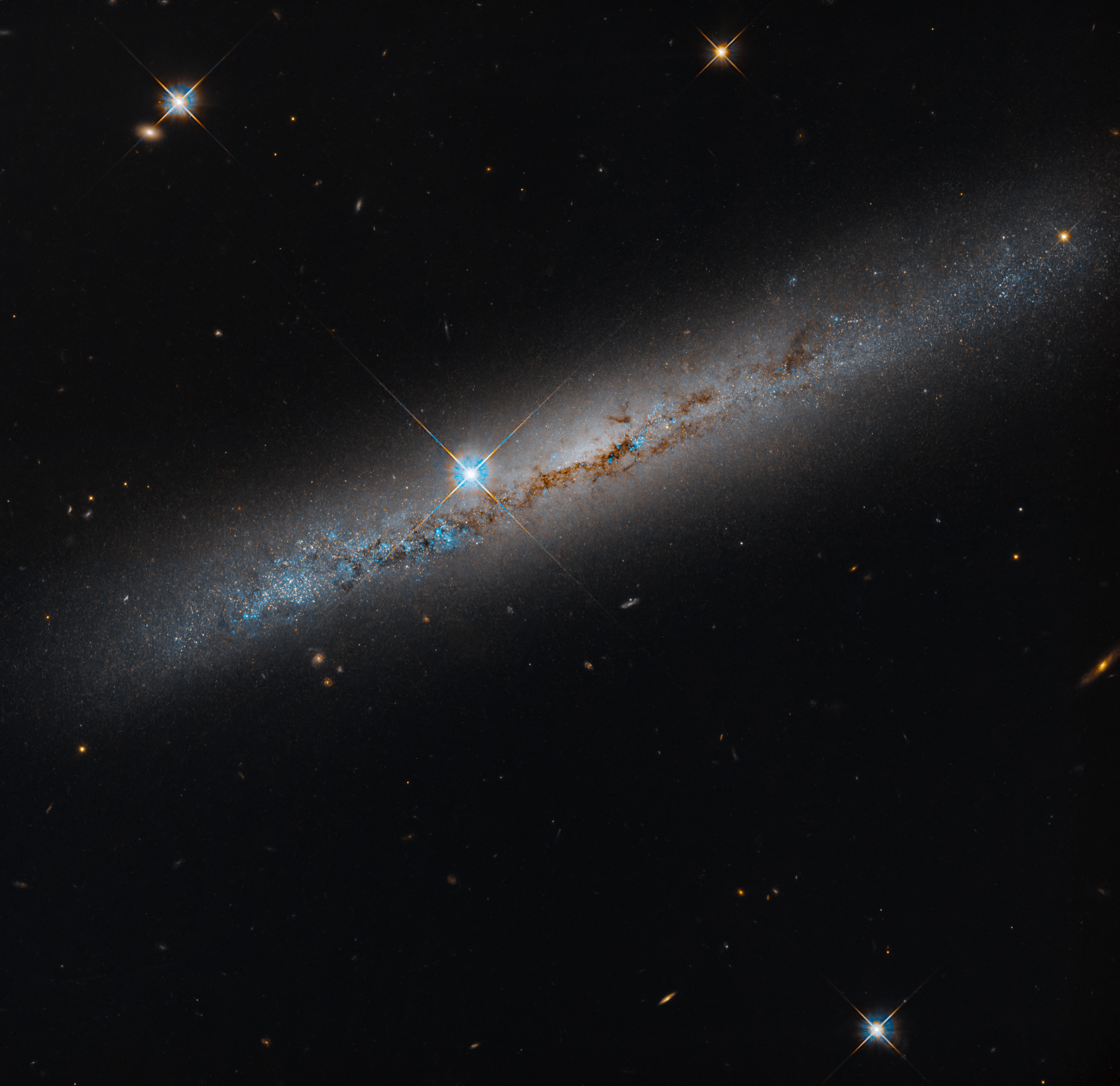
An edge-on spiral galaxy. Its rusty-brown dust lanes bisect the galaxy lengthwise. Bright-blue points dot the galaxy and seem to be more dense on its left side. A bright foreground star shines just to the left of the galaxy's center. The background is black and dotted with distant galaxies and a smattering of foreground stars, which are easily identified by their diffraction spikes.
This NASA Hubble Space Telescope image features the edge-on, intermediate spiral galaxy NGC 1827. Its rusty-brown dust lanes bisect the galaxy lengthwise. Look for distant galaxies that dot the black background, while a smattering of foreground stars are easily identified by their diffraction spikes.
NASA, ESA, Michael Jones (California Institute of Technology); Image Processing: Gladys Kober (NASA/Catholic University of America)

This NASA Hubble Space Telescope image features the edge-on, intermediate spiral galaxy NGC 1827, located roughly 37 million light-years away in the constellation Columba, the Dove. Hubble captured the image as part of a survey looking at 260 satellite galaxies around 22 Milky Way-like host galaxies within a radius of about 32 million light-years from Earth. Hubble has already observed 111 of these satellite galaxies. The remaining galaxies will take an additional 149 Hubble orbits, one orbit for each galaxy, to observe.

The image, taken with Hubble’s Advanced Camera for Surveys, reveals bright-blue regions along the galaxy’s disk dotted with dark dust lanes where new stars are likely forming. A bright foreground star appears just to the left of the galaxy’s bright central bulge but is located between us and the galaxy. Its four diffraction spikes are the result of light bending around the internal supports that hold Hubble’s secondary mirror.

Low-mass galaxies like the ones in this Hubble observing program provide a way to test the predictions of cosmological models on small scales, which struggle to match observations. The data Hubble gathers will help us better understand and characterize the properties of low-mass galaxies in Milky Way-like systems, allowing researchers to refine cosmological models.

Media Contact:

Claire Andreoli
NASA’s Goddard Space Flight Center, Greenbelt, MD
claire.andreoli@nasa.gov

APOD: 2026 October 16 – Chasing the International Space Station

16 Ottobre 2026 ore 06:05

APOD

Astronomy Picture of the Day

Discover the cosmos! Each day a different image or photograph of our fascinating universe is featured, along with a brief explanation written by a professional astronomer.

Chasing the International Space Station

Explanation: Blasting into the predawn sky on Tuesday, October 13, a Falcon 9 rocket and Dragon spacecraft are headed for low Earth orbit in this stunning timelapse video captured from Indian Harbour Beach, Florida. Starting with a launch from Space Launch Complex 40 at Cape Canaveral Space Force Station, Falcon and Dragon are chasing the International Space Station on NASA’s 35th Commercial Resupply Services mission. On cue, the space station itself enters the frame from the top. Almost 8 seconds into the 30 second timelapse. the bright streak of the ISS appears heading “down” toward the horizon. The first and second stages of the Falcon 9 are separating as the spectacular exhaust plume jellyfish grows, already catching the light of the rising Sun. The visible sequence of first stage boost back, re-entry, and landing burns begins around 20 seconds into the video. With the second stage following the ISS toward the distant horizon, the jellyfish plume continues to drift in the predawn sky, even after the successful first stage landing at planet Earth’s Landing Zone 40.

Tomorrow’s picture: pixels in space

Date October 16, 2026
Video Credit: Eric Holland
Authors & editors: Jerry Bonnell, Cecilia Chirenti, Robert Nemiroff, Keighley Rockcliffe
A service of: ASD at NASA / GSFC,
NASA Science Activation & Michigan Tech. U.

Isaias Dims the Gulf Coast

16 Ottobre 2026 ore 06:00


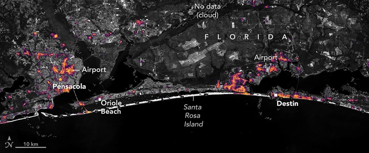
August 2026 Composite
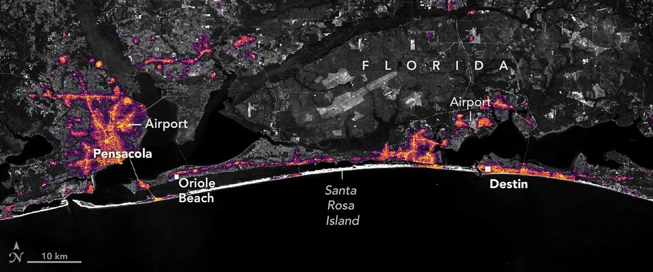
October 11, 2026

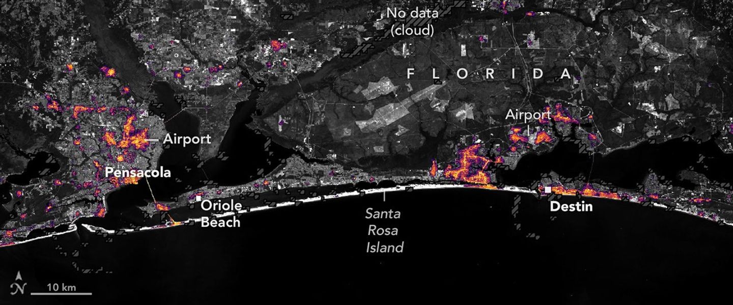
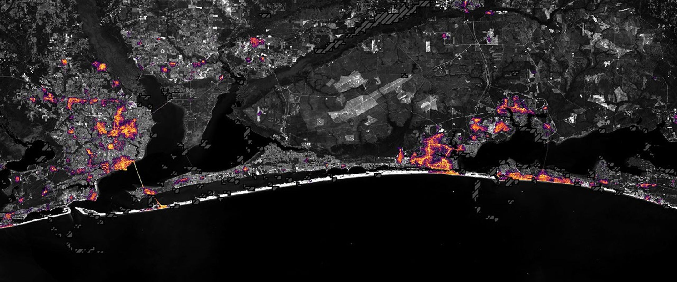
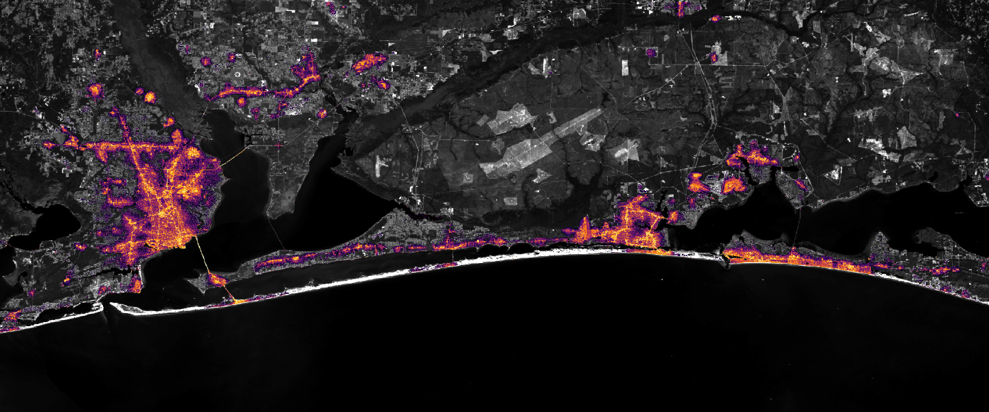
Nighttime lights along the Florida Panhandle coast in August 2026, brightest in Pensacola and Destin and along the road between them.
NASA Earth Observatory / Lauren Dauphin

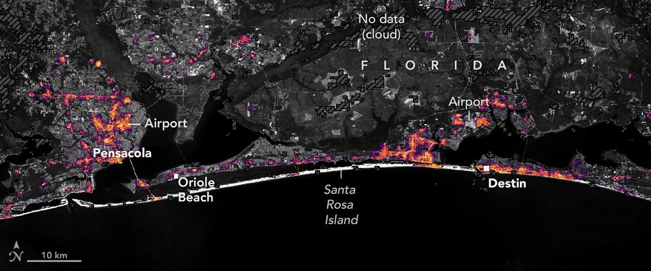
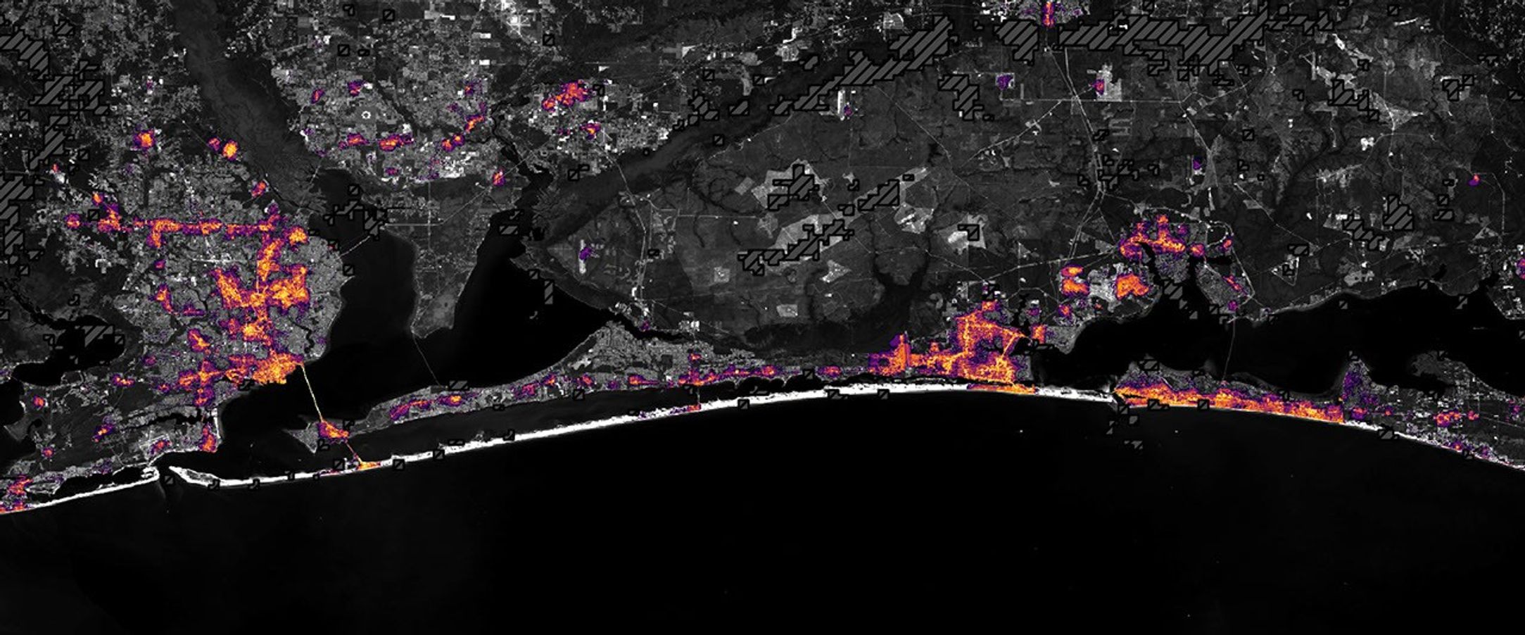
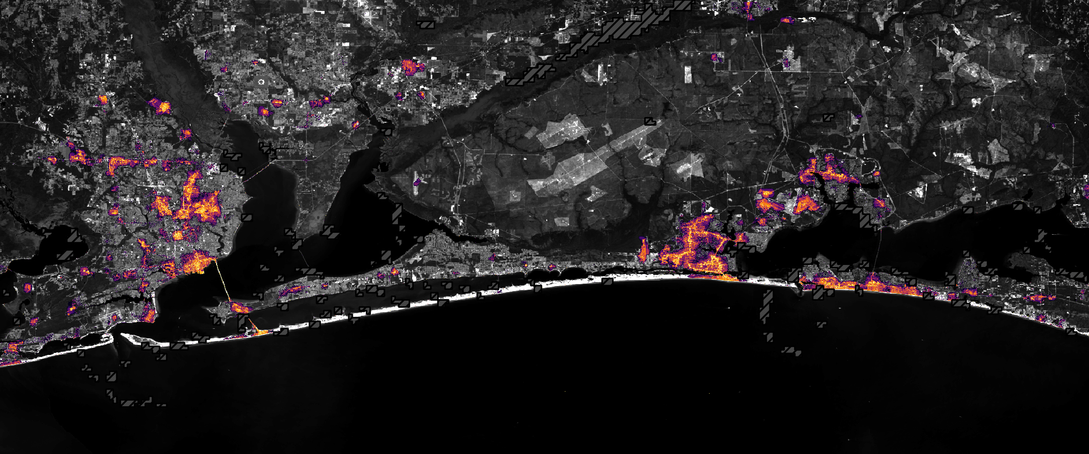
Nighttime lights along the Florida Panhandle coast on October 11, 2026, after Hurricane Isaias, with fewer and dimmer lights in Pensacola and Destin and gaps along the road between them.
NASA Earth Observatory / Lauren Dauphin

Nighttime lights along the Florida Panhandle coast in August 2026, brightest in Pensacola and Destin and along the road between them.
NASA Earth Observatory / Lauren Dauphin
Nighttime lights along the Florida Panhandle coast on October 11, 2026, after Hurricane Isaias, with fewer and dimmer lights in Pensacola and Destin and gaps along the road between them.
NASA Earth Observatory / Lauren Dauphin

August 2026 Composite

October 11, 2026


Lights around Pensacola, Florida, and along the U.S. Route 98 corridor toward Destin appear sharply reduced on October 11, 2026 (right), compared with typical conditions in August 2026 (left), suggesting widespread power outages after Hurricane Isaias. Images are from NASA’s Black Marble HD product.

After a quiet start to the 2026 Atlantic hurricane season, Isaias became the season’s first hurricane on October 8 as it tracked toward the U.S. Gulf Coast. The storm brought heavy rain and flash flooding to parts of the Southeast, including Alabama and the Florida Panhandle, and winds that toppled trees and downed power lines, leaving many people in the dark.

Isaias made landfall near Destin, Florida, on the evening of October 9 as a Category 2 hurricane with maximum sustained winds of 105 miles (170 kilometers) per hour. Gusts topped 100 miles per hour along a corridor west of the storm’s center, according to the National Weather Service, with preliminary reports showing a 117-mile-per-hour gust in Oriole Beach and a 102-mile-per-hour gust at Pensacola City Hall.

These areas of high winds overlapped a broader area west of the storm’s eye where satellite images showed substantial decreases in nighttime lights. The image pair above shows nighttime lights before and after the storm. The left image is a composite of August 2026 data representing typical conditions, and the right image shows lights on October 11, after most of the storm’s clouds had cleared.

The data depicted in the images, provided by Ranjay Shrestha of NASA’s Black Marble science team, come from the Black Marble HD product. The product uses data from the VIIRS (Visible Infrared Imaging Radiometer Suite) on the NOAA-20 satellite, which has a day-night band that detects light emitted and reflected at night. The team processed the data to account for changes in the landscape, the atmosphere, and phase of the Moon, and to filter out stray light that does not come from electric lights. Dark gray, hash-marked areas show where clouds prevented VIIRS from collecting data. The nighttime lights are shown over a base map from the Landsat 9 satellite.

“Standard Black Marble nighttime lights imagery, available through NASA Worldview, provides a broad picture of the storm’s immediate impacts,” Shrestha said. “Black Marble HD takes this a step further by allowing us to visualize these changes at a much finer spatial scale.”

At these finer scales, the images reveal lights decreasing sharply around parts of Pensacola, Florida, and along the U.S. Route 98 corridor toward Destin, suggesting widespread power disruptions. Shrestha also pointed out pockets where lights persisted, including Pensacola International Airport, Pensacola Christian College, and parts of downtown Pensacola. “These patterns could reflect backup power systems, differences in electrical infrastructure, or areas that maintained electricity during the storm, although the imagery alone cannot confirm the underlying reasons,” he said.


October 11, 2026
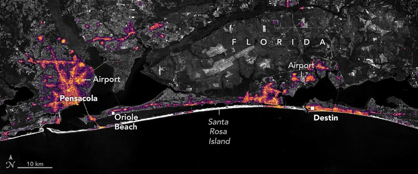
October 12, 2026

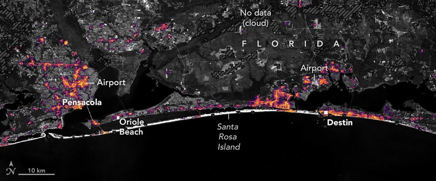
Nighttime lights along the Florida Panhandle coast on October 11, 2026, after Hurricane Isaias, with fewer and dimmer lights in Pensacola and Destin and gaps along the road between them.
NASA Earth Observatory / Lauren Dauphin

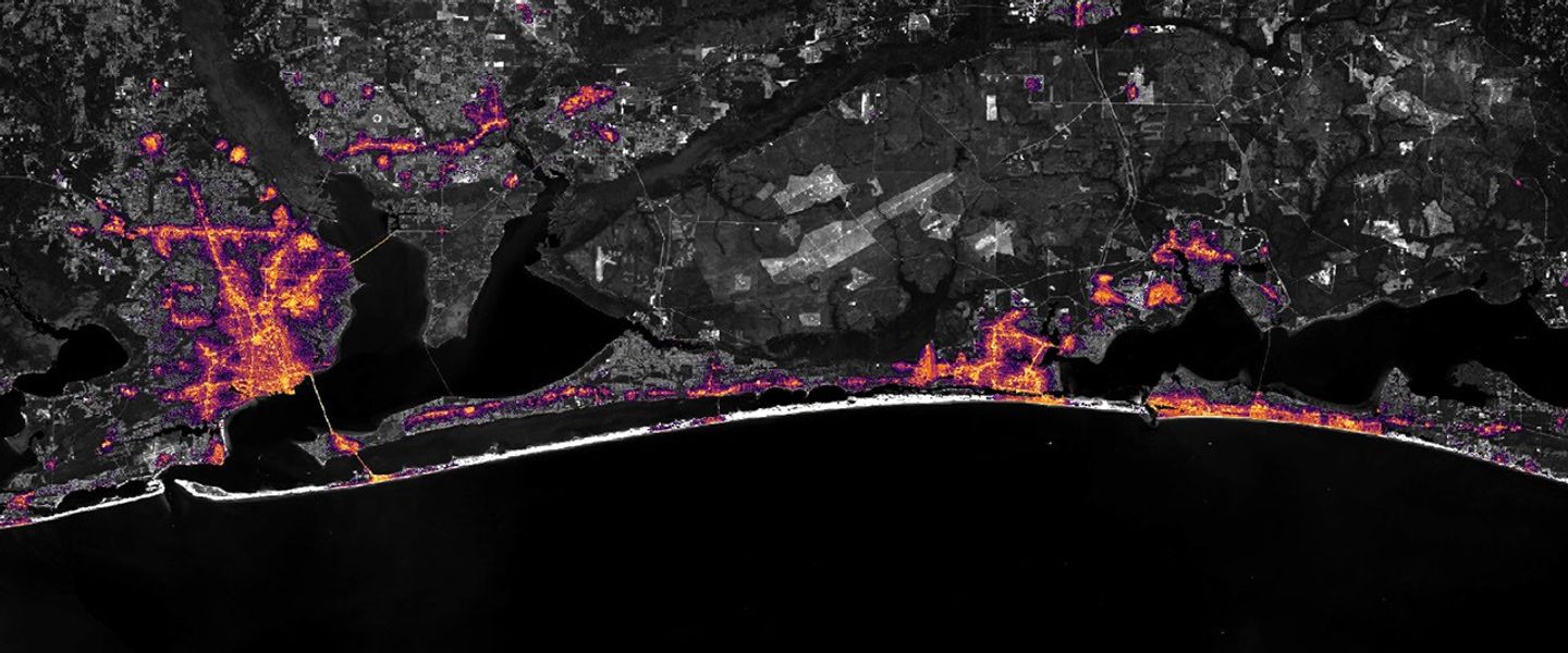
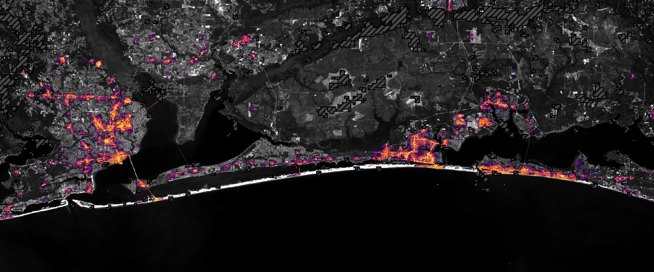
The same area on October 12, 2026, with lights in Pensacola and Destin and along the road between them closer to pre-storm levels.
NASA Earth Observatory / Lauren Dauphin

Nighttime lights along the Florida Panhandle coast on October 11, 2026, after Hurricane Isaias, with fewer and dimmer lights in Pensacola and Destin and gaps along the road between them.
NASA Earth Observatory / Lauren Dauphin
The same area on October 12, 2026, with lights in Pensacola and Destin and along the road between them closer to pre-storm levels.
NASA Earth Observatory / Lauren Dauphin

October 11, 2026

October 12, 2026


Widespread outages darken the region around Pensacola, Florida, and along the U.S. Route 98 corridor toward Destin on October 11, 2026 (left). By October 12 (right), lights have returned to some affected areas. Images are from NASA’s Black Marble HD product.

Black Marble HD images also reveal the pace and spatial patterns of recovery. The image pair above compares the same October 11 view (left) with one from October 12 (right), when lights had begun to return to some affected areas. By October 14, lighting patterns looked similar to pre-storm conditions.
 
“Understanding where recovery is progressing and where disruptions persist can help emergency responders and decision makers identify areas that may require additional attention, prioritize resources, and assess the effectiveness of restoration efforts,” Shrestha said.
 
Black Marble data complement ground-based outage reports rather than replace them, offering a more comprehensive view of disasters’ impacts and recovery. “Ultimately, this is where the value of Black Marble lies: turning nighttime Earth observations into actionable insights that support informed decisions and help bridge the gap between Earth science and action,” Shrestha said.
 
The NASA Disasters Program, in coordination with FEMA and the USGS Coastal Storms Team, is supporting the Alabama Red Cross and the Alabama Emergency Management Agency’s response to Hurricane Isaias. The team will be posting maps and data products on its open-access mapping portal as new information becomes available.

NASA Earth Observatory images by Lauren Dauphin, using Black Marble HD data courtesy of Ranjay Shrestha/NASA’s Goddard Space Flight Center and Landsat data from the U.S. Geological Survey. Story by Kathryn Hansen.

Downloads

Nighttime lights along the Florida Panhandle coast in August 2026, brightest in Pensacola and Destin and along the road between them.

August 2026 Composite

JPEG (558.38 KB)

Nighttime lights along the Florida Panhandle coast on October 11, 2026, after Hurricane Isaias, with fewer and dimmer lights in Pensacola and Destin and gaps along the road between them.

October 11, 2026

JPEG (1.10 MB)

The same area on October 12, 2026, with lights in Pensacola and Destin and along the road between them closer to pre-storm levels.

October 12, 2026

JPEG (1.14 MB)

References & Resources

You may also be interested in:

Stay up-to-date with the latest content from NASA as we explore the universe and discover more about our home planet.

Tropical Storm Arthur

2 min read

The first named storm of the 2026 Atlantic hurricane season brought intense rainfall and the threat of flash flooding to…

Article

Hurricane Simon Lurks Off the Mexican Coast

3 min read

Though it remained offshore, the storm lashed coastal areas with high winds and flooding—and produced remarkable rippling patterns in the…

Article

Powerful Storms Continue to Prowl the Pacific

4 min read

Hurricanes Polo and Nolo sent destructive effects ashore amid an active season in the northeastern and central Pacific.

Article
❌