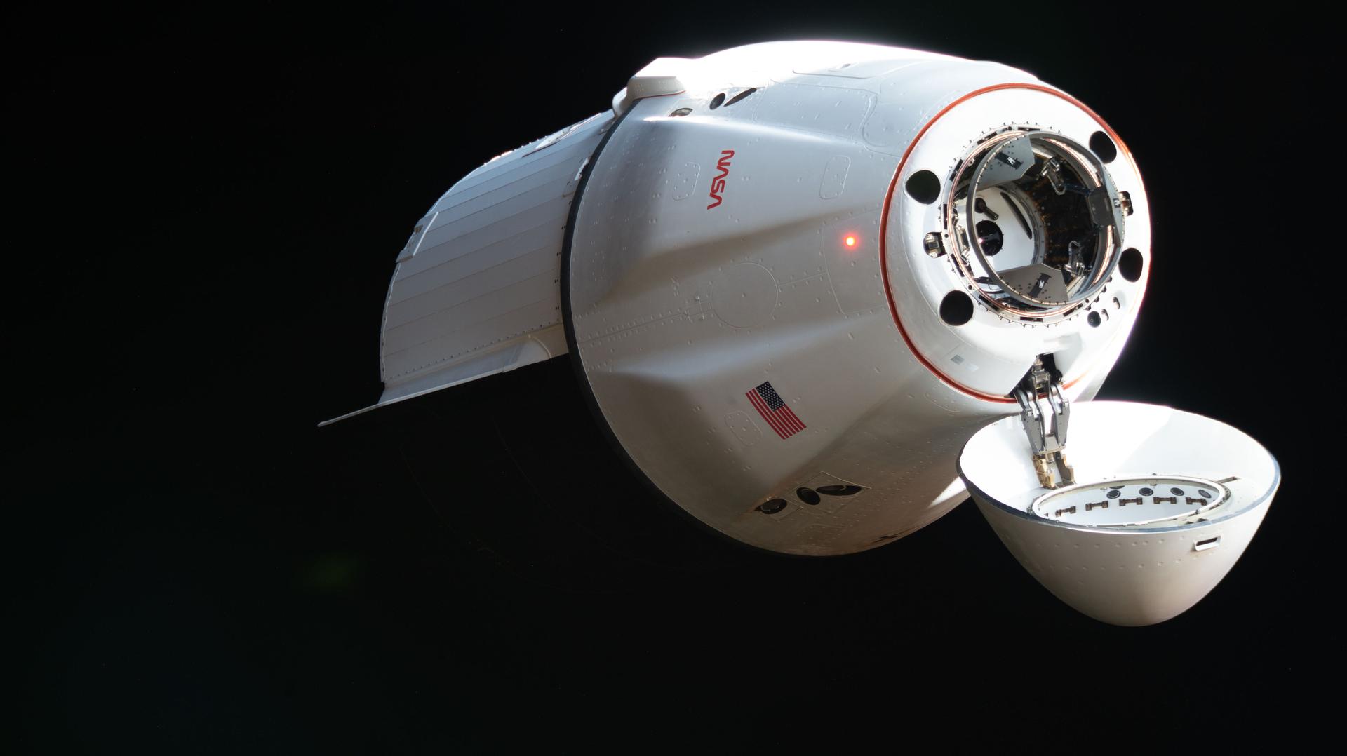
The SpaceX Dragon cargo spacecraft supporting the company’s 34th commercial resupply services mission for NASA approaches the International Space Station on May 17, 2026, carrying nearly 6,500 pounds of food, supplies, and equipment for the Expedition 74 crew.
Credit: NASA
NASA and its international partners are set to receive scientific research samples and hardware as a SpaceX Dragon spacecraft is scheduled to depart the International Space Station on Tuesday, June 16, for its return to Earth.
Watch NASA’s live undocking coverage beginning at 11:45 a.m. EDT on NASA+, Amazon Prime, and the agency’s YouTube channel. Learn how to watch NASA content through a variety of online platforms, including social media.
The Dragon spacecraft will undock from the forward port of the station’s Harmony module at about 12:05 p.m., after receiving a command from SpaceX ground controllers. The spacecraft then will fire its thrusters to move safely away from the orbiting complex.
Following a June 16 departure, the spacecraft will reenter Earth’s atmosphere on Wednesday, June 17, before splashing down off the coast of California at approximately 5:08 a.m. PDT. NASA will not stream the splashdown but will post updates on its space station blog.
Dragon will return to Earth with thousands of pounds of cargo, carrying samples that could shape future space exploration and life on Earth. Research returning includes bioprinted organ and cartilage tissue, data on improving cryogenic fuel storage for future space missions, and DNA‑inspired materials to develop new cancer treatments. The returning hardware includes an ocular imaging device used to monitor crew members’ eye health, an absorbent bed that filters trace contaminants from cabin air, and a separator pump from the waste and hygiene compartment.
Loaded with nearly 6,500 pounds of crew cargo and science experiments, Dragon arrived at the station on May 17 after launching two days earlier on a Falcon 9 rocket from Space Launch Complex 40 at Cape Canaveral Space Force Station in Florida.
For more than 25 years, people have lived and worked continuously aboard the International Space Station, advancing scientific knowledge and making research breakthroughs not possible on Earth. The space station helps NASA understand and overcome the challenges of human spaceflight, expand commercial opportunities in low Earth orbit, and build on the foundation for long-duration missions to the Moon, as part of the Artemis program, and to Mars.
Get breaking news, images, and features from the space station on Instagram, Facebook, and X.
Learn more about International Space Station research and operations at:
Easily identified by the spectacular band of dark dust that partially obscures its bright core, Messier 64, or the Black Eye Galaxy, is characterized by its bizarre internal motion.
NASA, CSA, ESA, F. Belfiore (European Southern Observatory – Germany), J. Lee (Space Telescope Science Institute), A. Leroy (The Ohio State University), and D. Thilker (The Johns Hopkins University); Processing: Gladys Kober (NASA/Catholic University of America)
This March 20, 2026, image of Messier 64, or the Black Eye Galaxy, is a composite view from NASA’s Hubble Space Telescope and James Webb Space Telescope. It shows Messier 64 captured at near- and mid-infrared wavelengths by Webb, while Hubble’s image shows the galaxy in ultraviolet, visible, and near-infrared light.
Messier 64 is characterized by its bizarre internal motion. The gas in the outer regions of this spiral galaxy is rotating in the opposite direction from the gas and stars in its inner regions. This strange behavior may be the result of a merger between M64 and a satellite galaxy over a billion years ago.
Image credit: NASA, CSA, ESA, F. Belfiore (European Southern Observatory – Germany), J. Lee (Space Telescope Science Institute), A. Leroy (The Ohio State University), and D. Thilker (The Johns Hopkins University); Processing: Gladys Kober (NASA/Catholic University of America)
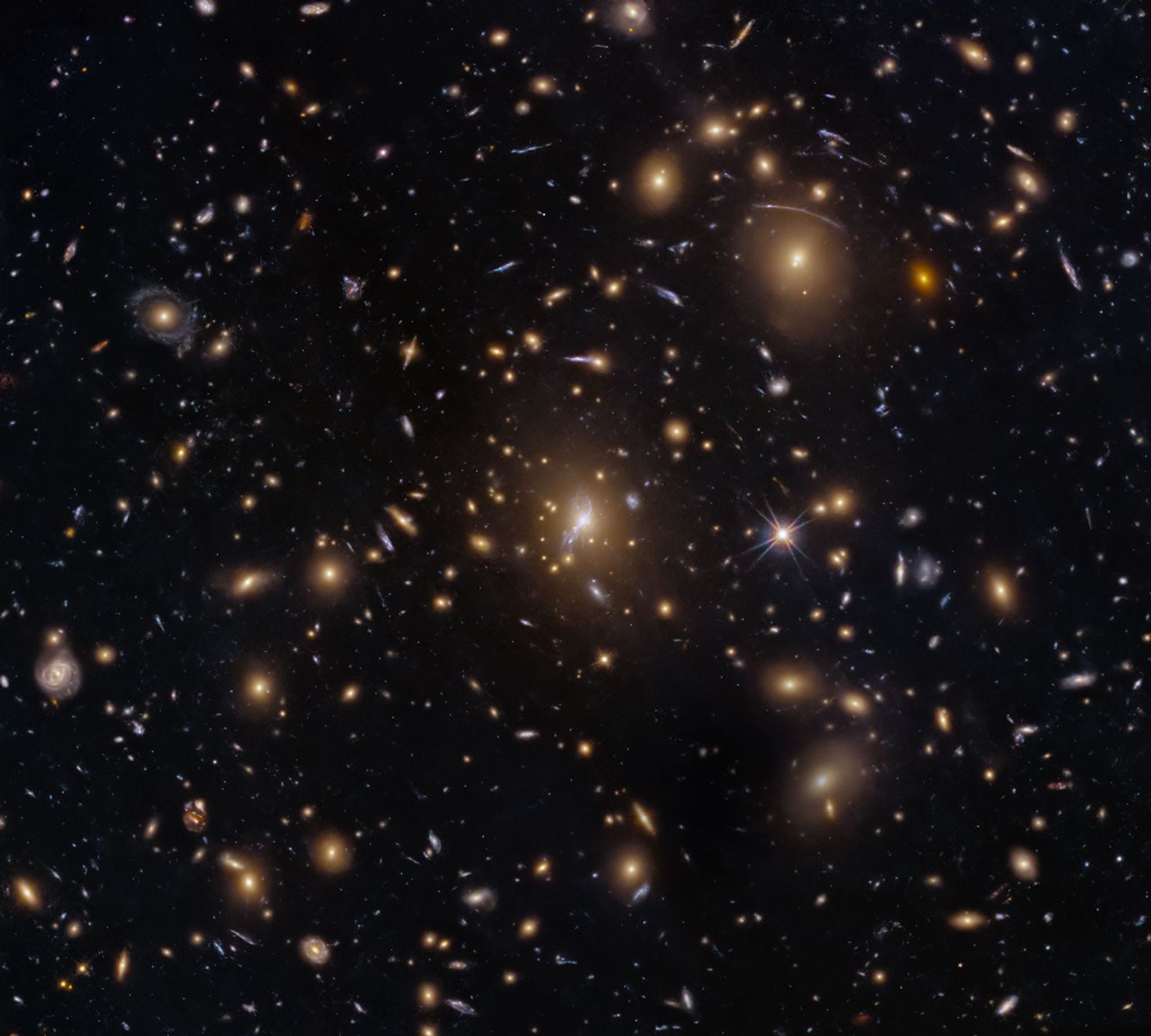
This NASA Hubble Space Telescope image features the galaxy cluster MACS0329-0211.
NASA, ESA, M. Postman (STScI); Image Processing: G. Kober (NASA/Catholic University of America)
Looking somewhat like a swarm of bees returning to their hive, this NASA Hubble Space Telescope image features the galaxy cluster MACS0329-0211. Galaxy clusters like MACS0329-0211 are important signposts in the story of how the structure of the universe evolved, and are the ultimate telescopic lenses, placing gravitationally lensed galaxies from the earliest stages of the universe into our view.
Zoom into this galaxy swarm and you will find large, oval-shaped elliptical galaxies, and thin spiral and lenticular galaxies viewed from the edge. We can also see the full, face-on view of spiral galaxies and their curving spiral arms. The image’s upper-right quadrant holds faint arcs of distant galaxies gravitationally lensed by the cluster’s massive gravity. The largest of these arcs appears above the bright oval shape of a giant elliptical galaxy. Closer inspection of the image’s center reveals several bright-white intersecting curves that appear as a distorted figure eight. This may be another distant galaxy whose light was magnified and distorted by this massive cluster’s gravity.
Hubble looked at MACS0329-0211 as part of an observing program of X-ray bright galaxy clusters. Researchers used Hubble’s two main cameras, the Advanced Camera for Surveys and its Wide Field Camera 3, to gather data visible and infrared light from the cluster. Hubble’s ability to see such a broad spectrum of light makes it a valuable tool in understanding the very nature of these galaxy clusters.
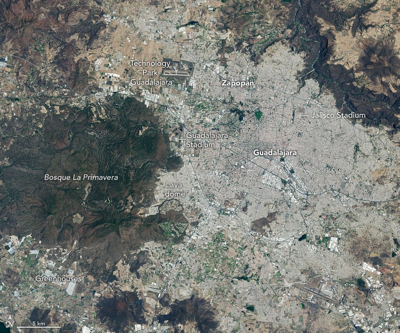
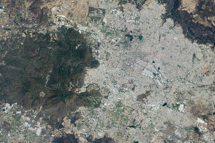
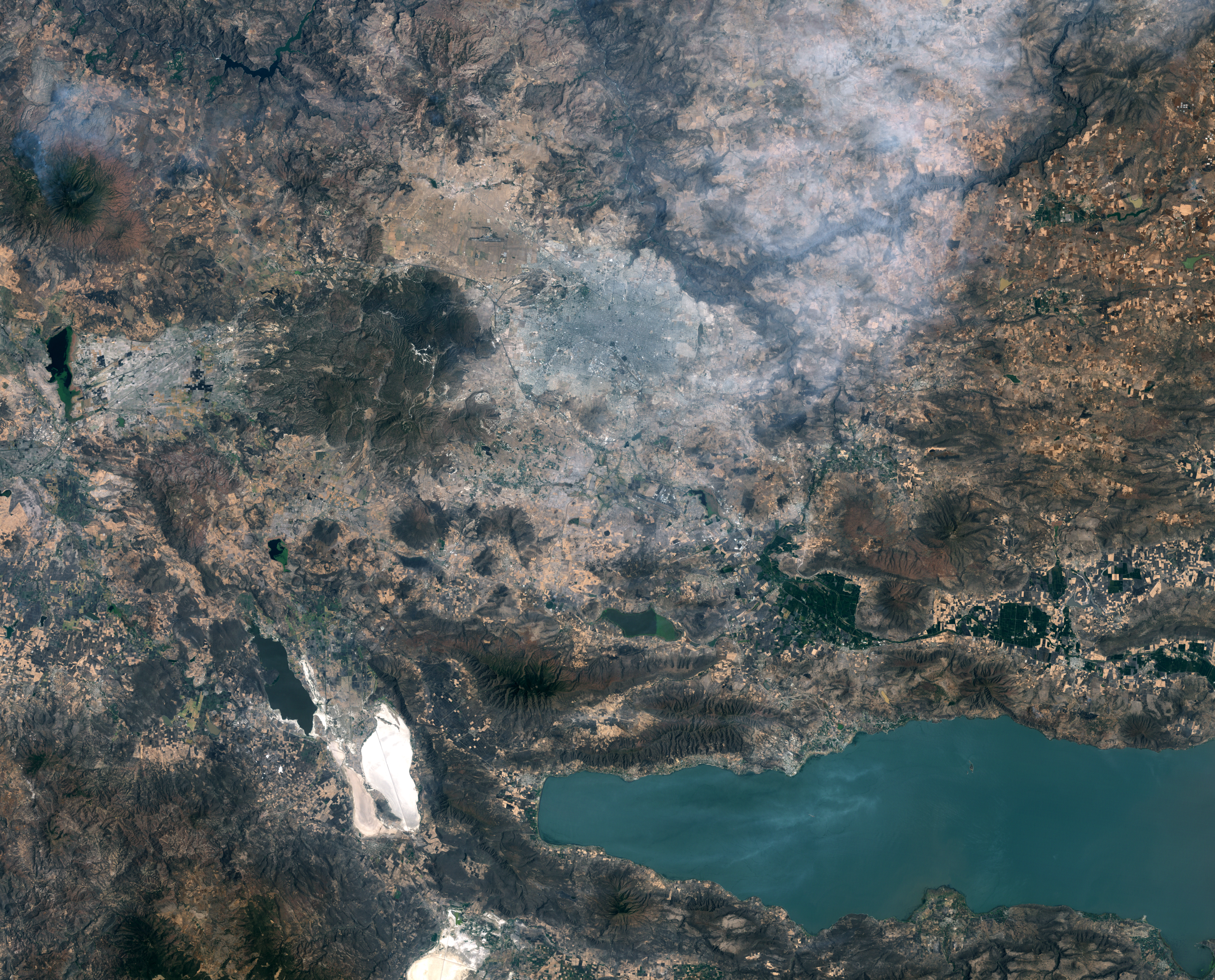
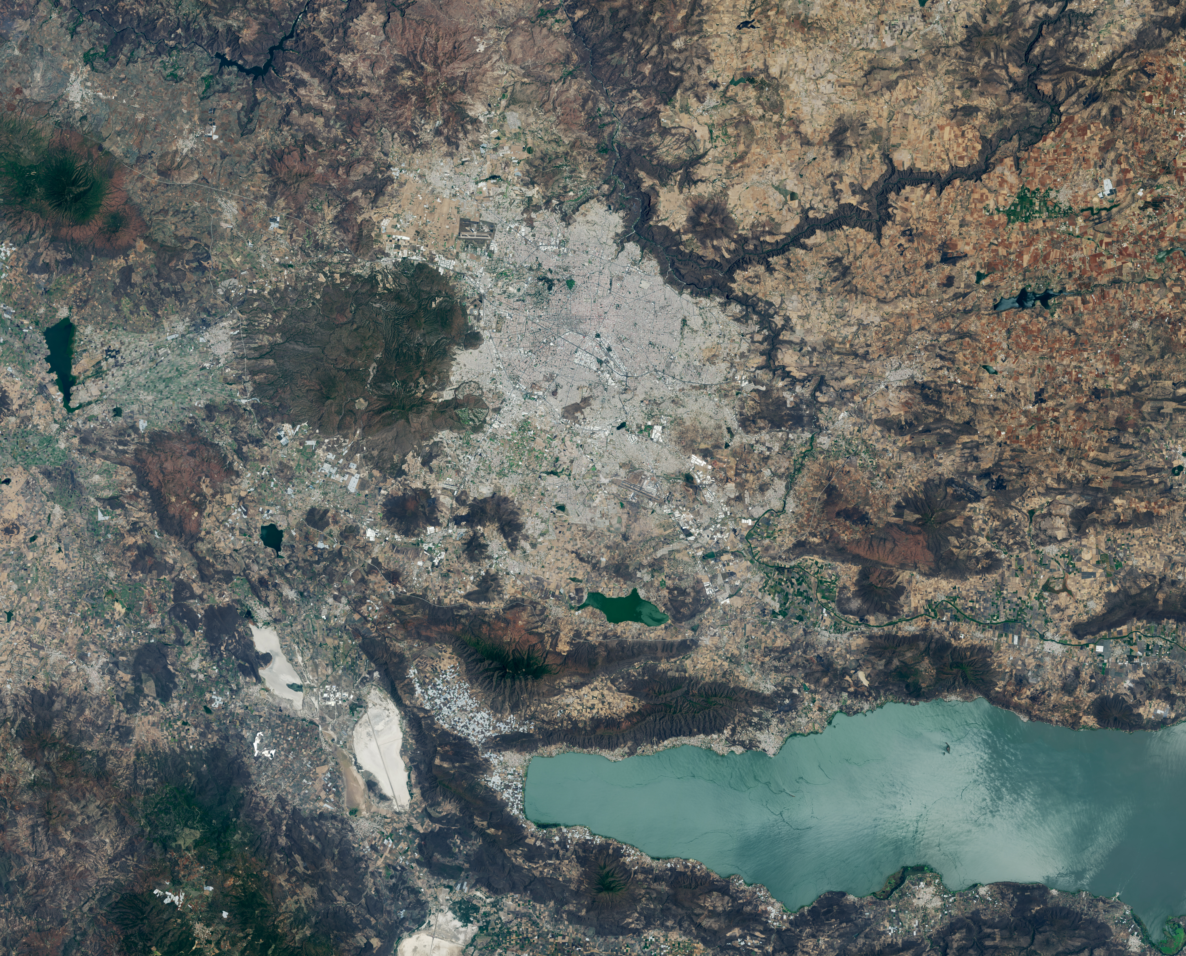
A pair of Landsat images shows 40 years of westward urban expansion from Guadalajara, Mexico. The Thematic Mapper on Landsat 5 captured the left image in 1986; the Operational Land Imager on Landsat 8 captured the right image in 2026.
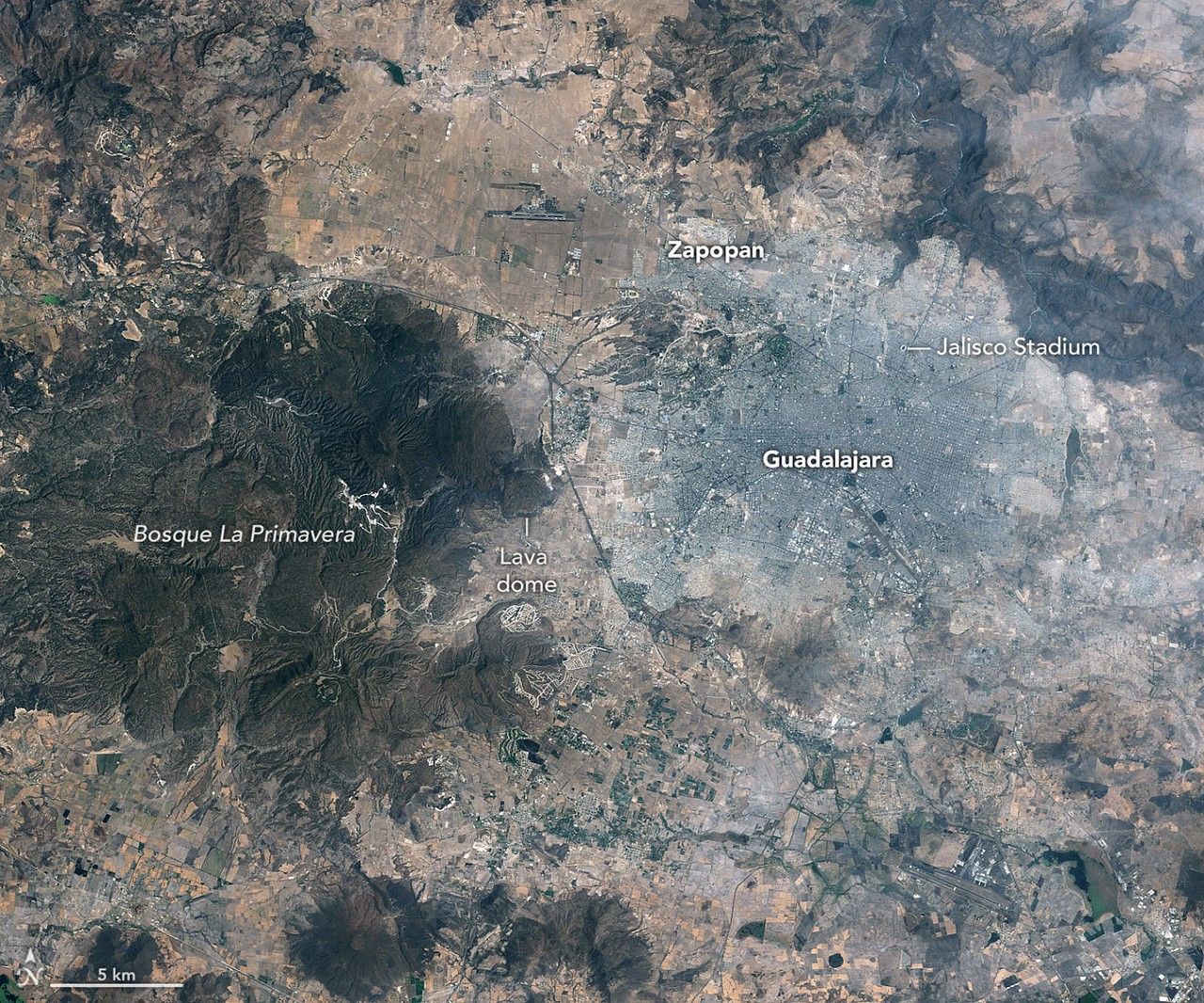
A pair of Landsat images shows 40 years of westward urban expansion from Guadalajara, Mexico. The Thematic Mapper on Landsat 5 captured the left image in 1986; the Operational Land Imager on Landsat 8 captured the right image in 2026.
NASA Earth Observatory / Lauren Dauphin
A pair of Landsat images shows 40 years of westward urban expansion from Guadalajara, Mexico. The Thematic Mapper on Landsat 5 captured the left image in 1986; the Operational Land Imager on Landsat 8 captured the right image in 2026.
A pair of Landsat images shows 40 years of westward urban expansion from Guadalajara, Mexico. The Thematic Mapper on Landsat 5 captured the left image in 1986; the Operational Land Imager on Landsat 8 captured the right image in 2026.
NASA Earth Observatory / Lauren Dauphin
April 13, 1986
April 27, 2026
April 13, 1986 – April 27, 2026
A pair of Landsat images shows 40 years of westward urban expansion from Guadalajara, Mexico. The TM (Thematic Mapper) on Landsat 5 captured the left image in 1986; the OLI (Operational Land Imager) on Landsat 8 captured the right image in 2026.
Guadalajara, Mexico, was quite a different place when it last hosted World Cup games 40 years ago. The city welcomed matches in June 1986 and did so again in 2026, when South Korea faced Czechia at Guadalajara Stadium in the opening round of the 2026 FIFA World Cup.
In 1986, Guadalajara Stadium had not yet been built in Zapopan, the fast-growing municipality just northwest of Guadalajara. Many of that year’s World Cup matches were held instead at Jalisco Stadium in northeastern Guadalajara. It was in that stadium that France defeated Brazil in a penalty shootout in the 1986 quarterfinals, in what is widely regarded as one of the most memorable World Cup games of all time.
As seen in the Landsat images above, the land where Guadalajara Stadium (also called Estadio Akron) now sits was farmland in 1986. The new stadium, built in 2010 to host Mexico’s Club Deportivo Guadalajara, or Chivas, lies near the Sierra la Primavera volcanic complex, a rugged landscape full of lava flows, volcanic domes, steam vents, and hot springs. The architects who designed the stadium took inspiration from the nearby volcanic terrain, creating a structure that rises from a grassy earthen berm meant to resemble the flanks of a volcano, topped with a white roof reminiscent of a volcanic cloud.
About 95,000 years ago, the volcanic system underneath Sierra la Primavera produced a massive eruption that caused a caldera 11 kilometers (7 miles) in diameter to slump downward. Water filled the depression for tens of thousands of years, but tectonic uplift and the accumulation of sediment eventually led to the demise of the lake. Erosion wore away the softer surrounding rock over time, leaving harder, erosion-resistant volcanic rocks within the circular feature that now stand high above the surrounding terrain.
Starting about 60,000 years ago, several lava domes erupted along the southern edge of the caldera. The youngest of them, Cerro del Colli, formed about 30,000 years ago, leaving the dome-shaped feature just south of the stadium and contributing to a broader landscape dotted with other volcanic domes and cinder cones.
Today, much of the original caldera has been preserved as a forested area known as La Primavera Biosphere Reserve, even as development has partially encircled it during the past 40 years. The population of the Guadalajara metro area has grown from about 2.7 million in 1986 to more than 5.5 million now, with particularly rapid growth in Zapopan, a burgeoning tech hub sometimes billed as “Mexico’s Silicon Valley.” A prominent development visible in Landsat images is Guadalajara Technology Park, one of several new industrial parks in Zapopan. New greenhouses have also come to the area en masse, including south of the reserve, where they are mostly used to grow fruits and vegetables.
World Cup fever runs particularly high in Guadalajara, which is hosting World Cup matches for the third time. During Brazil’s legendary title run in 1970, when Pelé led the team, Jalisco Stadium was the venue for Brazil’s first-round, quarterfinal, and semifinal matches. To commemorate him, the city in May 2026 erected a 9.5-meter (31-foot) bronze statue of the iconic football (soccer) player.
Even the animals at Guadalajara Zoo are taking part in the festivities, with elephants, gorillas, giraffes, capybaras, pumas, and macaws “predicting” match winners by choosing between food, shirts, boxes, soccer balls, and other items. A puma named Muluk predicted South Korea would beat Czechia by sniffing and moving a ball, one newspaper reported.
Guadalajara will host four first-round matches: South Korea vs. Czechia on June 12, Mexico vs. South Korea on June 18, Colombia vs. Democratic Republic of the Congo on June 23, and Uruguay vs. Spain on June 26.
NASA Earth Observatory images by Lauren Dauphin, using Landsat data from the U.S. Geological Survey. Story by Adam Voiland.
NASA Award Boosts Space Technology Research Capabilities
NASA is introducing a new funding opportunity to accelerate academic research and technology development. The Minority University Research and Education Project Space Technology Artemis Research (M‑STAR) application window opened Thursday and will remain open through 11:59 p.m. EDT on Tuesday, Aug. 11.
The research funded through this award supports the agency’s priorities for exploring the Moon, Mars, and deep space, while strengthening eligible institutions in the future of space exploration. Through M-STAR, institutions are encouraged to grow their scientific and engineering capabilities, enhance faculty and student engagement in aerospace research, and expand their ability to compete for future federal and commercial research awards.
Administered by NASA’s Office of STEM Engagement, this initiative contributes to NASA’s Space Technology Mission Directorate, and supports the agency’s broader mission to develop innovative technologies that improve space transportation, human exploration, robotic discovery, and the growing space economy.
NASA’s Office of STEM Engagement fosters an ecosystem across education, industry, and government to cultivate a well‑prepared talent pool, while the agency’s Space Technology Mission Directorate develops the transformative space technologies that enable future NASA missions and ensure U.S. leadership in aerospace. Together, they accelerate mission readiness by aligning cutting edge technological innovation with the workforce needed to carry it forward.
For complete eligibility information, help session registration, and to submit an M-STAR proposal, visit:
NASA’s Chandra Discovers Possible Supernova Remnant in Galactic Center
Using data from NASA’s Chandra X-ray Observatory, astronomers may have found a supernova remnant in an intriguing neighborhood in the middle of our galaxy. A paper describing these new findings published in The Astrophysical Journal.
Supernova remnants are the expanding remains of exploded stars and provide elements – like iron, oxygen, and silicon – that are critical for the formation of planets and for life as we know it to form and flourish.
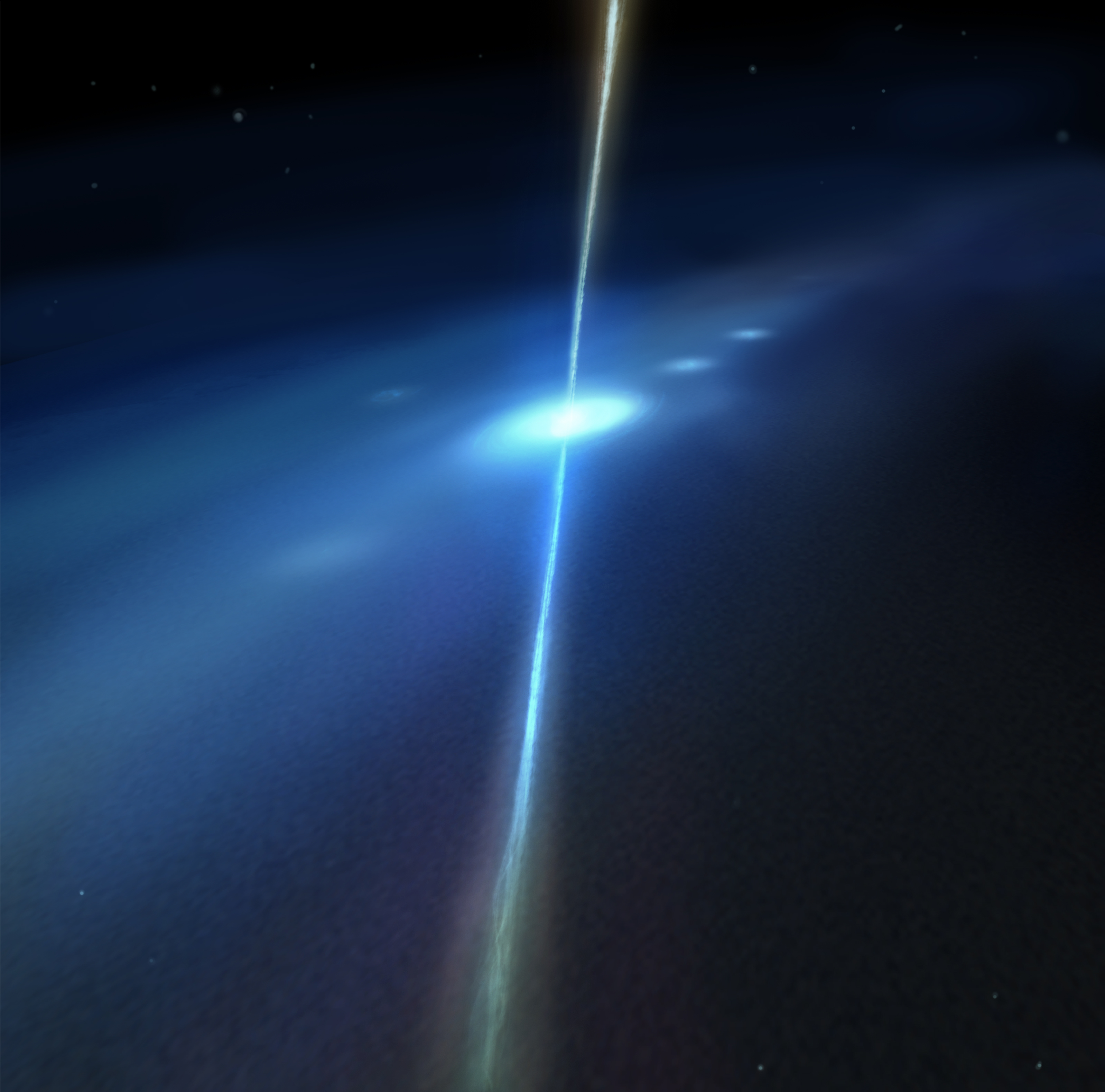
This new supernova remnant, if confirmed, would be one of the closest ever discovered to the supermassive black hole at the central region of the Milky Way galaxy, an exotic region crammed with massive stars, long threads of magnetic fields and dense clouds of gas orbiting rapidly around the Galactic Center.
Astronomers may have uncovered a new supernova remnant in a star-forming region near the center of the Milky Way galaxy using data from Chandra and XMM-Newton. If confirmed, this would be one of the closest supernova remnants to the supermassive black hole in the Galactic Center. This image shows the region where the evidence was found, which contains X-rays from Chandra and XMM-Newton, radio data from the MeerKAT telescope in South Africa, and an optical image from the Pan-STARRS telescopes in Hawaii.
X-ray: NASA/CXC/UCLA/Z. Zhu et al.; ESA/XMM-Newton; Optical: PanSTARRS; Radio: MeerKAT; Infrared (JWST): NASA/ESA/CSA/STScI; Image Processing: NASA/CXC/SAO/L. Frattare and P. Edmonds
A new composite image of this region contains X-rays from Chandra and ESA’s (European Space Agency’s) XMM-Newton mission (shown in blue) as well as radio data from the MeerKAT telescope (shown in red) in South Africa. These have been combined with an optical image from the Pan-STARRS telescopes in Hawaii (red, green, and blue). The plane of the galaxy runs horizontally from left to right in the image, and the central black hole is off to the left of the image.
The evidence for the new supernova remnant, located about 26,000 light-years from Earth, comes from X-ray data from Chandra and XMM-Newton. The X-ray data reveals a “blob” of X-ray emission that may come from the remains of a massive star that self-destructed as a supernova, buried within the larger cloud of expanding gas.
The location of this suspected supernova remnant in the image is labeled with a circle.
It is in a bubble of gas that has had electrons stripped away from hydrogen – called an “H II region” – surrounding a massive, young star. This bubble is a bright source of radio emission called Sagittarius C.
If this is indeed a supernova remnant, then it is expanding at about two million miles per hour and is at least about 1,700 years old. Previously, observations with NASA’s now-retired SOFIA (Stratospheric Observatory for Infrared Astronomy) mission had shown evidence for an expanding shell of gas surrounding Sagittarius C. This gave astronomers a hint that a stellar explosion had occurred in the same spot.
The long filaments seen in the radio image are caused by energetic particles travelling along magnetic fields that are mostly directed perpendicular to the plane of the galaxy.
The nuclear fusion engines of stars create elements from hydrogen and helium that were abundant at the beginning of the universe. When stars explode at the end of their lives as supernovae, they send these newly synthesized elements into interstellar space and provide material for the next generation of stars and planets.
The team of astronomers searched the X-ray data for signs of increased amounts of key elements in the remnant, which would have been caused by the stellar explosion blasting them into space. While they did not see an enhancement, this could imply that the stellar debris has already mixed with the surrounding gas.
An alternative explanation for the X-ray blob is that the hot gas comes from a collection of massive stars in the region. The authors of the recent study don’t think this explanation is likely, because the X-ray emission from the blob is more than ten times brighter than the X-ray emission of large, known stellar clusters with bright, massive stars.
An additional image shows data from NASA’s James Webb Space Telescope added to the X-ray and radio data. The light blue color represents infrared light from gas in the H II region, and the darker blue depicts X-rays from the supernova remnant candidate, on the right side of the image. X-rays near the center of the image are associated with the H II region, possibly caused by material blown away by massive stars that has heated gas to millions of degrees, producing X-rays.
Sagittarius C, close-up image adding NASA’s James Webb Space Telescope data to the X-ray and radio data.
The study’s authors are Zhenlin Zhu and Mark Morris of the University of California, Los Angeles; Gabriele Ponti of Italy’s National Institute for Astrophysics; and Ping Zhou of Nanjing University in China.
NASA’s Marshall Space Flight Center in Huntsville, Alabama, manages the Chandra program. The Smithsonian Astrophysical Observatory’s Chandra X-ray Center controls science operations from Cambridge, Massachusetts, and flight operations from Burlington, Massachusetts.
Visual Description
This release features a composite image of colorful, overlapping clouds, which suggests to astronomers that a supernova remnant may be buried in gas near the center of our Milky Way galaxy.
Set against a backdrop packed with distant stars and other specks of light are two distinct, overlapping clouds. The larger, visually dominant cloud, is red and multifaceted. It has an irregular shape, and features patches of different textures, including pockets that resemble wispy smoke, tangles of faint red veins, and clear streaking lines. This large cloud of expanding gas represents radio data from the MeerKAT telescope in South Africa.
Overlapping with that red cloud is a cloudy blue blob representing X-ray data from NASA’s Chandra X-ray Observatory and ESA’s XMM-Newton. Astronomers suggest that this blue blob of X-ray emissions is the remains of a massive star destroyed by a supernova.
Listen to this audio excerpt from Elkin Norena, resident management officer, NASA’s Space Launch System Program:
0:00 / 0:00
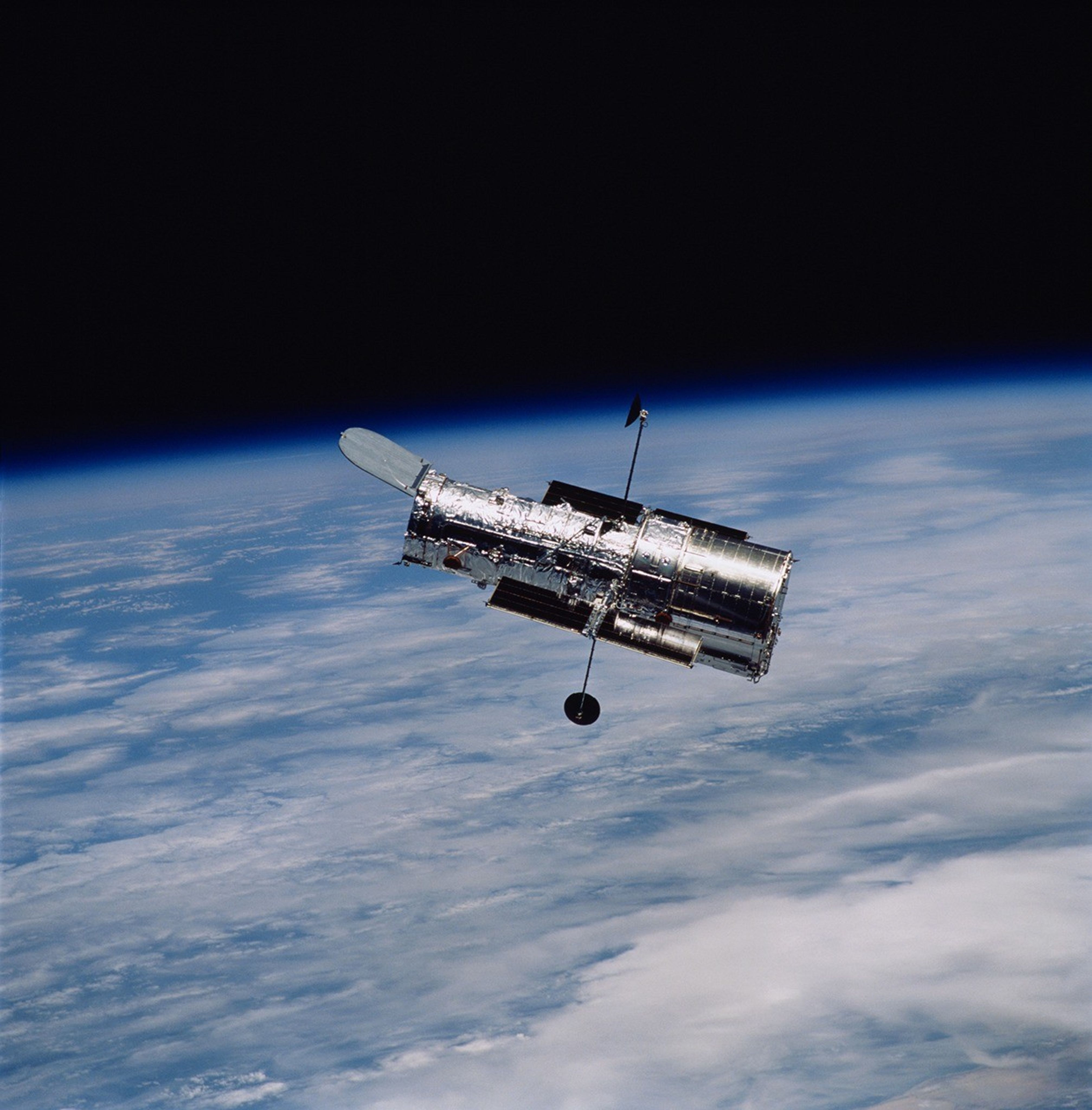
NASA’s Elkin Norena has helped the agency launch more than a dozen space shuttle missions – that’s more than a dozen crews to low Earth orbit and more than a dozen historic missions. They were missions that helped build the International Space Station, that provided a final servicing mission to the Hubble Space Telescope, and that performed critical science experiments that improved life right here on Earth.
Today, he continues that work as the manager of the Resident Management Office for SLS at NASA’s Kennedy Space Center in Florida, helping launch America’s rocket – the SLS (Space Launch System) – and the Orion spacecraft with its international quartet of astronauts on the Artemis II mission to fly by the Moon and return home.
Elkin Norena, who serves as an SLS resident management officer at NASA’s Kennedy Space Center in Florida, stands in front of an RS-25 engine.
NASA
As resident manager, Norena provides onsite SLS support for NASA’s Exploration Ground Systems team that is responsible for preparing, stacking, testing, and launching SLS and Orion. He is also the eyes and ears for the SLS Program, providing an avenue of communications back to the program, which is managed at NASA’s Marshall Space Flight Center in Huntsville, Alabama.
It is the continuation of a childhood dream to be part of space exploration.
“When I was a kid in New Jersey, I watched a space shuttle launch in class one day,” said Norena. “When I watched the power of launch and the brave astronauts going to explore, I knew I had to be a part of that one day. I wanted to become an astronaut.”
The dream to join the space program led the Colombia native to the University of Central Florida in Orlando, where he majored in computer engineering, just miles from the Space Coast and in view of space shuttle launches like the ones he once watched on TV.
When that clock ticks down to T-10 minutes, everybody’s just waiting. You wait for the automated system to kick in. You hold your breath and watch the clock go down to T-0. Then BOOM, launch happens, and you know it was all worth it.
Elkin Norena
Resident management officer, NASA Space Launch System Program
Following college, he joined NASA contractor United Space Alliance at NASA Kennedy, and in 2008 he joined the NASA Kennedy team as a civil servant, working on the same spacecraft that inspired him to pursue the space program as a child.
“I started off in the Space Shuttle Program as an electrical engineer. Then I moved into the firing room for 17 different shuttle missions as a flight termination engineer. It was exciting to be part of all those missions and build the International Space Station,” Norena said.
The Milky Way stretches above Dry Tortugas National Park in Florida.
Elkin Norena
Using those experiences, he became one of the original SLS team members. He was a part of the teams that successfully launched Artemis I and II and is now critical to the upcoming Artemis III mission.
Away from the launch pad, Norena’s hobbies orbit around his teenage daughters, participating in their activities. He also keeps a keen eye on space and is an avid astrophotographer.
“I love capturing the Milky Way! I’ve traveled to Utah, New Mexico, Arizona, and all across the western United States,” he said. “A great spot that’s closer for me is Dry Tortugas National Park beyond Key West.”
No matter how he explores space, Norena believes Artemis II is more than just a mission.
“This is historic. I grew up watching the shuttle missions, learning about Apollo, and wanting to be part of those Moon missions. We built the space station. The space shuttle explored space and technology on many levels,” he said. “Now, it’s our turn with Artemis to get back to the Moon, and this time to stay there. I’m excited to be part of the generation that does that.”
NASA Robotic Tech Demo Will Advance Prototype Gamma-Ray Detectors
A new type of gamma-ray sensor developed by NASA, called AstroPix, will take part in a robotic arm demonstration on the agency’s upcoming Fly Foundational Robots mission, set to launch in late 2027.
Gamma rays are the highest-energy form of light. Scientists observe them coming from events like lightning in Earth’s atmosphere, powerful solar flares from our Sun, and cosmic collisions in distant galaxies. The sensors on the AstroPix technology demonstration are designed to measure gamma rays between 20,000 and 700,000 electron volts. For comparison, visible light’s energy falls between 2 and 3 electron volts.
But for energies between 500,000 to 1 million electron volts, existing detectors are less sensitive. This range is where many powerful explosions called gamma-ray bursts shine the brightest. It’s also where astronomers expect to see the strongest glow from the most massive and distant active galaxies powered by black holes. By stacking AstroPix detectors in future missions, scientists could bridge this gap and improve observations of these cosmic objects to better understand the processes that create and drive them.
“The Fly Foundational Robots spacecraft is also a technology demonstration, so the projects were a good fit for each other,” said Dan Violette, an AstroPix team member and post-doctoral fellow at NASA’s Goddard Space Flight Center in Greenbelt, Maryland. “We need to thoroughly test AstroPix’s performance before we can use the sensors in future science missions. We’ve flown comparable technologies on a scientific balloon mission, and the current prototype eventually will be part of a sounding rocket payload. Many of those flight opportunities only reach near space, though. It’s not often that technology demonstrations like ours can find a ride into orbit.”
Each AstroPix chip has four silicon pixel gamma-ray detectors. Each of these detectors incorporates 1,225 pixels. AstroPix detectors, which are developed by NASA’s Goddard Space Flight Center in Greenbelt, Md., function similarly to the sensors in cellphone cameras except they are sensitive to gamma-ray light.
Image courtesy of Argonne National Laboratory
Each AstroPix chip contains four silicon pixel gamma-ray detectors, and each detector incorporates 1,225 pixels. The chips function similarly to the sensors in cell phone cameras.
The AstroPix Satellite Technology dEmonstration Payload, also known as A-STEP, will be hosted within the Fly Foundational Robots mission’s Orbital Replacement Unit, a movable module built by Rocket Lab Robotics. Rocket Lab Robotics also will provide a robotic arm that will pick up and reposition the unit during flight and perform in-orbit operations as part of a robotic servicing demonstration. The A-STEP payload will collect its data following the repositioning. Astro Digital will provide the spacecraft.
The Orbital Replacement Unit was designed to support power and data interfaces for a payload, but the original plan called for the robotic arm to reposition the module without one. As mission development progressed, however, the Fly Foundational Robots team identified an opportunity to further maximize the mission’s value by integrating an additional technology demonstration that could fit within the 11.8-inch (30-centimeter) cube.
“The unit already had the volume, power, and data needed to support the AstroPix team’s design,” said Bo Naasz, senior technical lead, In-space Servicing, Assembly, and Manufacturing in the Space Technology Mission Directorate at NASA Headquarters in Washington. “One of our major goals with Fly Foundational Robots is to demonstrate robotic changeout of payloads in orbit, enabling upgrades or improvements to satellites and space instruments at a fraction of the cost of a full mission. Allowing AstroPix to complete its own technology demonstration in orbit is a bonus.”
NASA’s Fly Foundational Robots mission will be hosted aboard a spacecraft provided by Astro Digital of Littleton, Colo., as shown in this artist’s concept. The robotic arm, provided by Motiv Space Systems in Pasadena, Calif., will perform a technology demonstration in orbit, including picking up and moving a small box containing the agency’s AstroPix gamma-ray sensors.
Rocket Lab Robotics
The AstroPix team is working to deliver their hardware this September, and it will be integrated into the Fly Foundational Robots payload before final integration onto the spacecraft. The Orbital Replacement Unit will hold the chips and all the associated electronics needed to provide power, and collect and transmit data during flight.
NASA’s Fly Foundational Robots mission is funded through the Space Technology Mission Directorate’s ISAM portfolio, managed at NASA Goddard. Rocket Lab Robotics will supply the mission’s robotic arm system through a NASA Small Business Innovation Research Phase III award. Astro Digital will host the orbital flight test of the arm through NASA’s Flight Opportunities program, managed at NASA’s Armstrong Flight Research Center in Edwards, California. The development of AstroPix was supported by NASA’s Astrophysics Division in the Science Mission Directorate at NASA Headquarters, through the agency’s Astrophysics Research and Analysis Program, and funded through the Nancy Grace Roman Technology Fellowship.
A soccer ball floats in microgravity in this March 2, 2026, picture from the International Space Station. The space station crew tested soccer balls to study how internal mass affects motion and stability in microgravity. The findings have improved understanding of how embedded technologies, including match-ball sensors, can influence performance during play.
Preparations for Next Moonwalk Simulations Underway (and Underwater)
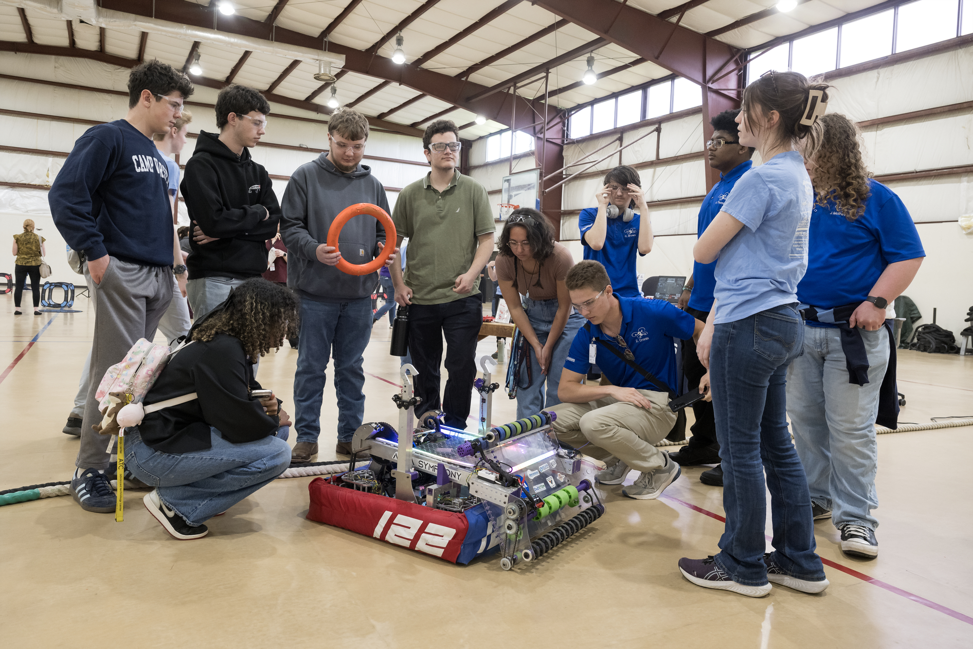
Students participate in a hands-on robotics demonstration during Career Technical Education Day at NASA’s Langley Research Center in Hampton, Virginia.
NASA/Mark Knopp
At NASA, remaining a global leader in exploration and innovation includes having a skilled and dedicated workforce. Technicians play a critical role in advancing the agency’s research and missions, applying hands-on expertise across engineering, fabrication, electronics, and countless other technical fields.
To help cultivate the next generation of technical talent, NASA’s Office of STEM Engagement hosted Career Technical Education Day recently at NASA’s Langley Research Center in Hampton, Virginia. One hundred high school and community college students from Virginia and North Carolina attended, eager to explore the technical career paths that help drive NASA’s work.
“Many students picture NASA as only astronauts or engineers and therefore never consider a career at NASA to be within their reach,” said Bonnie Murray, lead for the Office of STEM Engagement at NASA Langley. “Bringing students from local career and technical education programs to Langley allows them the opportunity to see technicians at work, hear the pathways those technicians followed, and understand how the skills they are developing in their related classes have a place in the NASA workforce.”
The event opened with remarks from NASA Langley’s Steve Gayle, who traced his path from an engineering technician co-op in the center’s Fabrication Division and a graduate of Langley’s Engineering Technician Apprentice Program to his current role as acting associate director. Gayle encouraged students to embrace challenges, think critically, stay curious, and create their own opportunities as they pursue their career goals.
“We need young, bright minds,” Gayle said. “At NASA, we rely on skilled hands-on professionals — technicians who operate our wind tunnels, apply their skills in our fabrication shops, and use their electronics knowledge to design, test, and build critical systems.”
Students visit NASA Langley Research Center’s model shop during Career Technical Education Day to learn about the materials and techniques technicians use to build model aircraft and spacecraft.
NASA/Ryan Hill
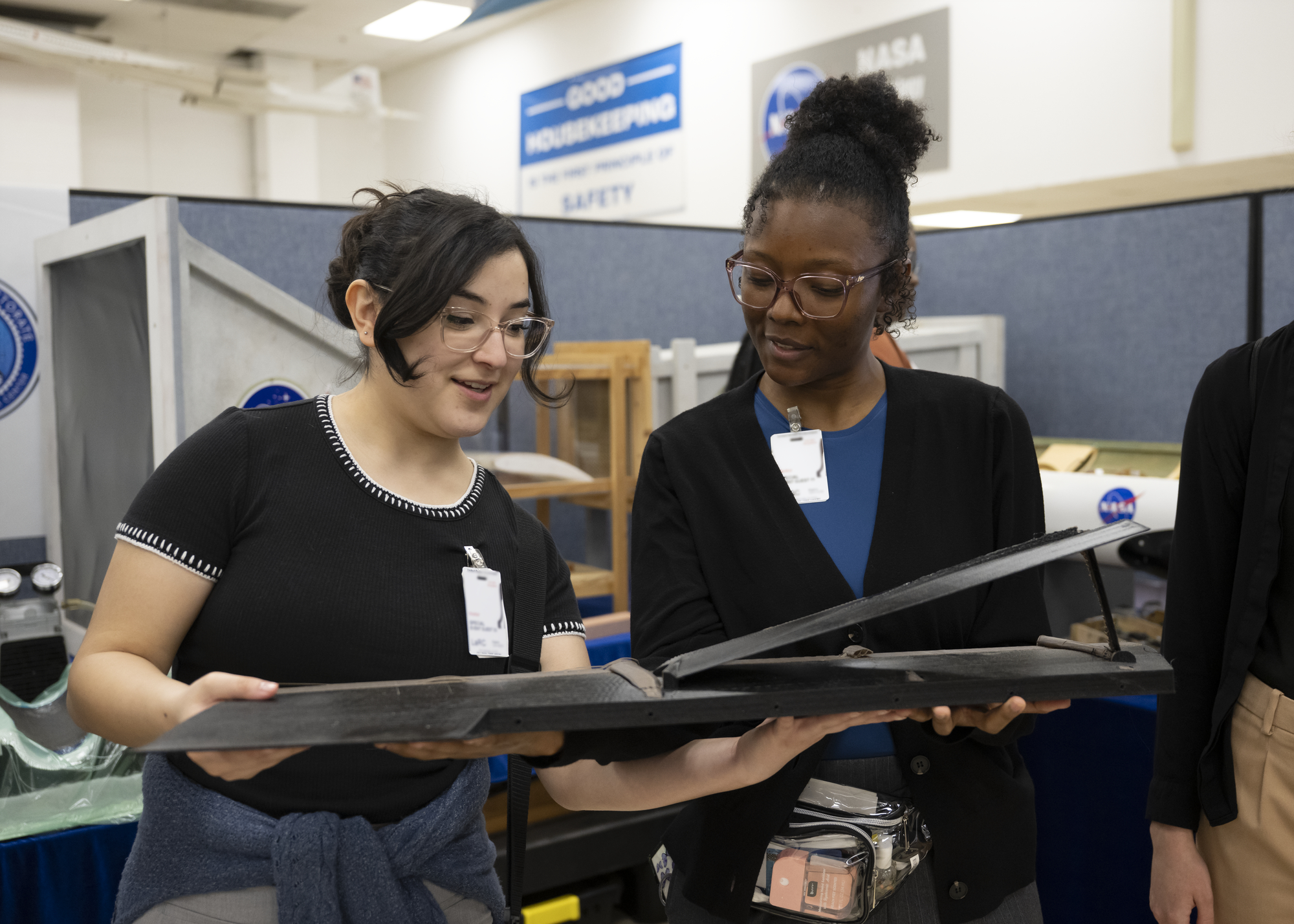
Throughout the day, students toured several of Langley’s world-class facilities, including the historic Landing and Impact Research Facility and one of the center’s wind tunnels. At each stop, they received a behind-the-scenes look at the spaces where NASA technicians build, test, and refine the tools and technologies that support the agency’s missions. The technicians spoke with students about their work, their career paths, and the skills needed to excel in technical roles.
Hands-on demonstrations and interactive activities lead by NASA technicians and aerospace industry partners helped students connect their classroom experience with real-world applications. Whether observing fabrication techniques, seeing instrumentation up close, or engaging with engineering demonstrations, participants experienced how STEM and technical skills directly translate into meaningful careers.
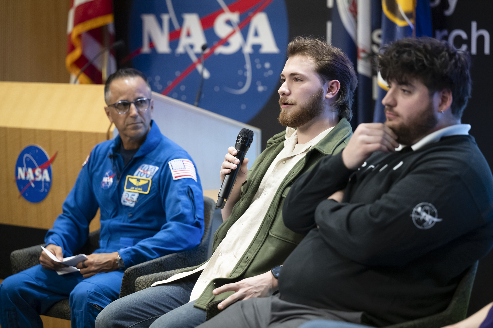
“Through events such as this, NASA seeks to prepare students for aerospace careers through experiences and investments that strengthen research capacity, build technical expertise, and expand reach in alignment with agency missions and needs,” Murray said. The event ended with a career panel moderated by NASA astronaut Joe Acaba, associate director of mission and strategy at NASA’s Johnson Space Center in Houston and former math and science teacher. The panel featured four Langley technician apprentices who shared insights into their roles and the value of strong foundational skills in technical fields.
Wyatt Healy, mechanical engineering technician apprentice at NASA’s Langley Research Center, answers questions during a career panel featuring NASA Langley technician apprentices during Career Technical Education Day.
NASA/Ryan Hill
“A basic grasp of how software, systems, and even everyday items function goes a long way as you progress in your technician journey,” said Wyatt Healy, mechanical engineering technician apprentice at NASA Langley. “When you have those fundamentals down, learning the more advanced concepts becomes much easier. It doesn’t happen overnight, but with a strong foundation, the sky is the limit.”
By connecting students with NASA professionals, facilities, and hands-on experiences, the event showcased a broad range of opportunities available in technical careers. It also underscored NASA’s commitment to building a strong, skilled workforce equipped to support the agency’s mission and tackle the challenges of tomorrow.
For more information about opportunities to connect students with NASA’s mission, work, and people, visit:
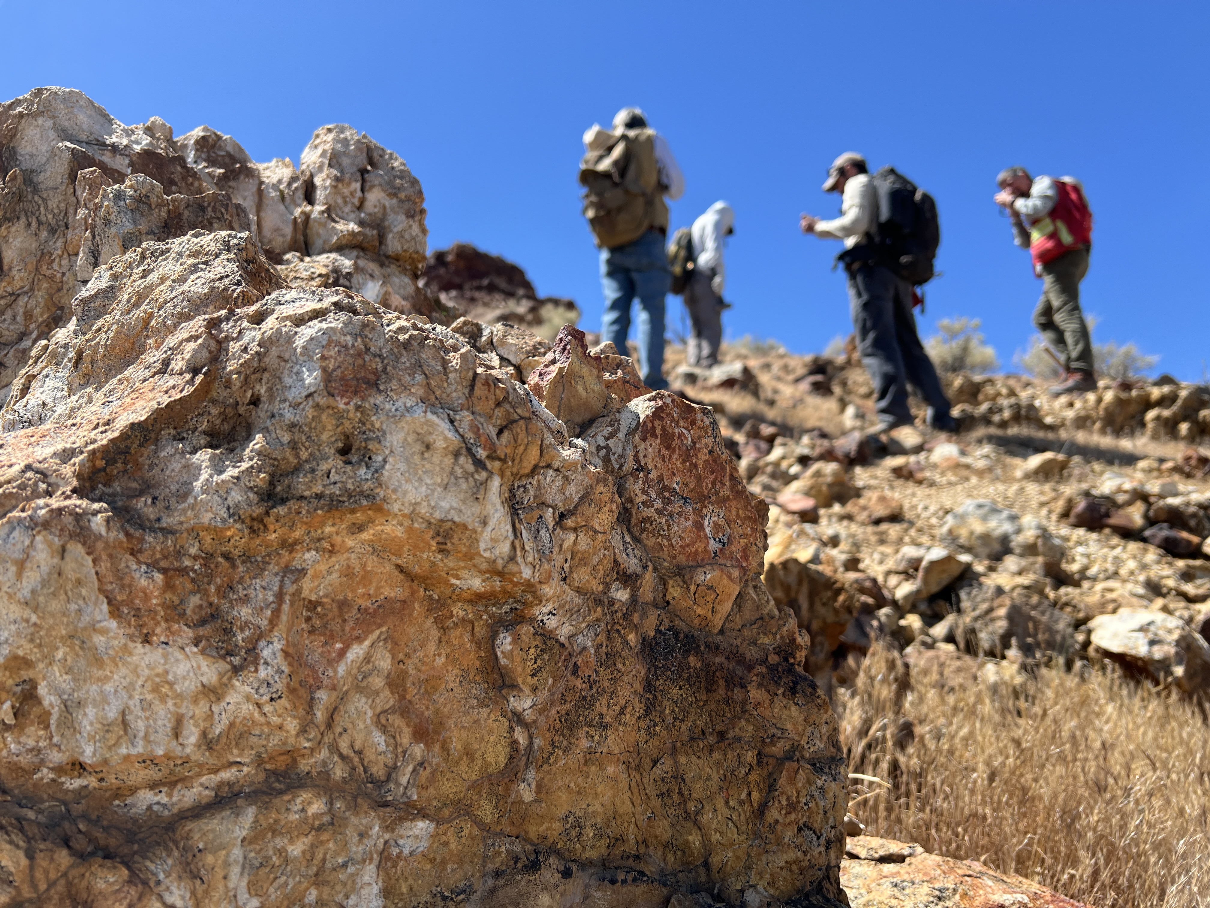
Geologists recently converged on a site near Barstow, California, to ground-truth a mineral discovery made on public land by a NASA JPL sensor flying aboard a plane overhead.
NASA/JPL-Caltech
Equipped with rock picks and hand lenses, a team of geoscientists deployed to the Mojave Desert recently to investigate a tantalizing “fingerprint” detected by a NASA sensor. Their target: a cache of topaz hiding in plain sight.
The geologists weren’t searching for gem-grade treasure. Rather, the presence of topaz could hint at a more valuable deposit below of something known as porphyry copper.
One of the world’s primary sources of copper, these deposits are left behind when magma and hot water from deep underground course through Earth’s crust, chemically transforming the surrounding rock. This tends to occur where one tectonic plate dives below another, known as a subduction zone, such as the North American Cordillera, which stretches from the Canadian Rockies to western Mexico.
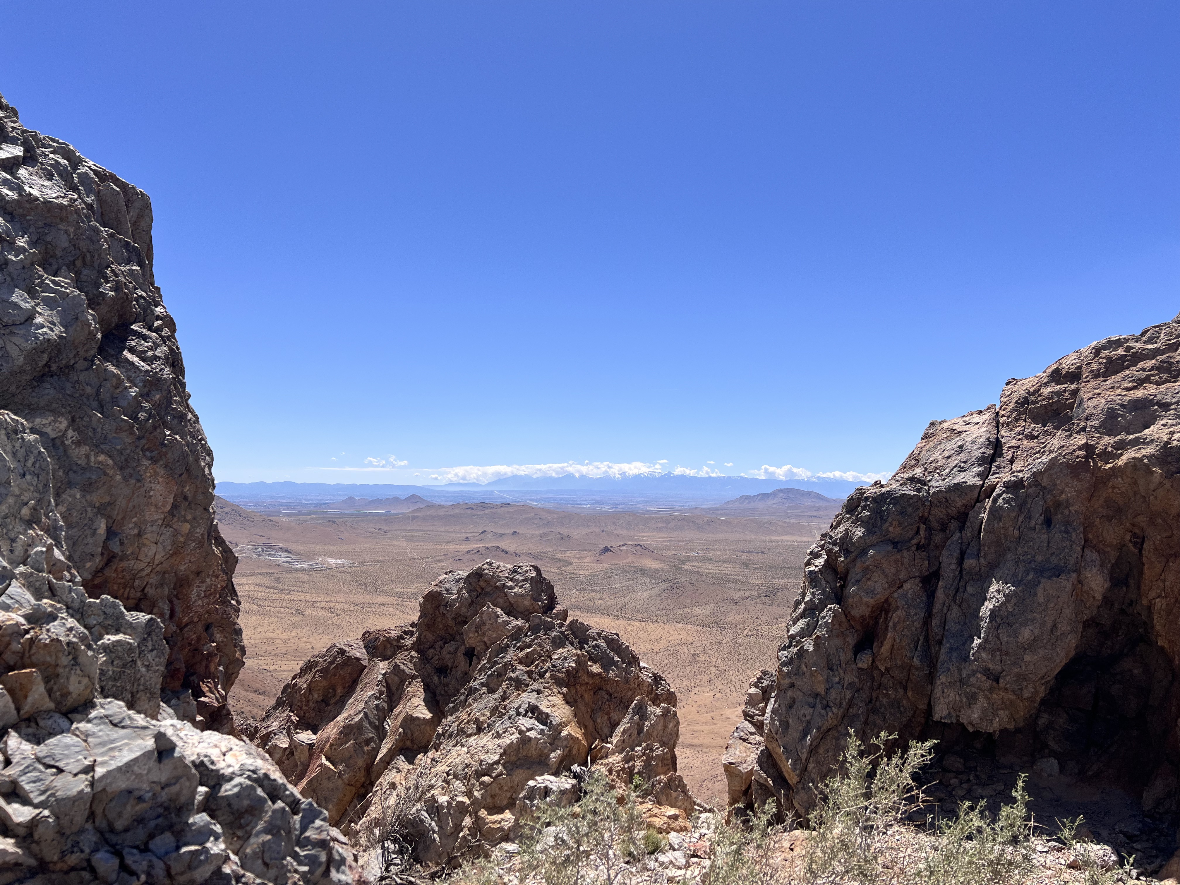
California’s high desert stretches below a bright spring sky in April 2026. NASA and USGS scientists are using airborne remote sensing to home in on potential sources of critical minerals here and across the Western U.S.
NASA/JPL-Caltech
In addition to copper — the third most used metal in the world after steel and aluminum — the deposits can hold other critical minerals like molybdenum and tellurium, which are used in everything from steelmaking to solar panels. Finding the deposits isn’t easy. Geologists look for topaz because it forms under the same volcanic conditions.
For the team in the Mojave, the goal was to collect more evidence. That would require boots on the ground and a heavy bag of samples. The scientists who converged on the site included three experts from the U.S. Geological Survey (USGS) and Robert Green of NASA’s Jet Propulsion Laboratory in Southern California.
“What we’re doing out here is geologic CSI,” said Green, referring to the investigative TV show, as he split open a weathered red rock to expose a sparkling core. “We’re looking for clues to reconstruct what happened here.”
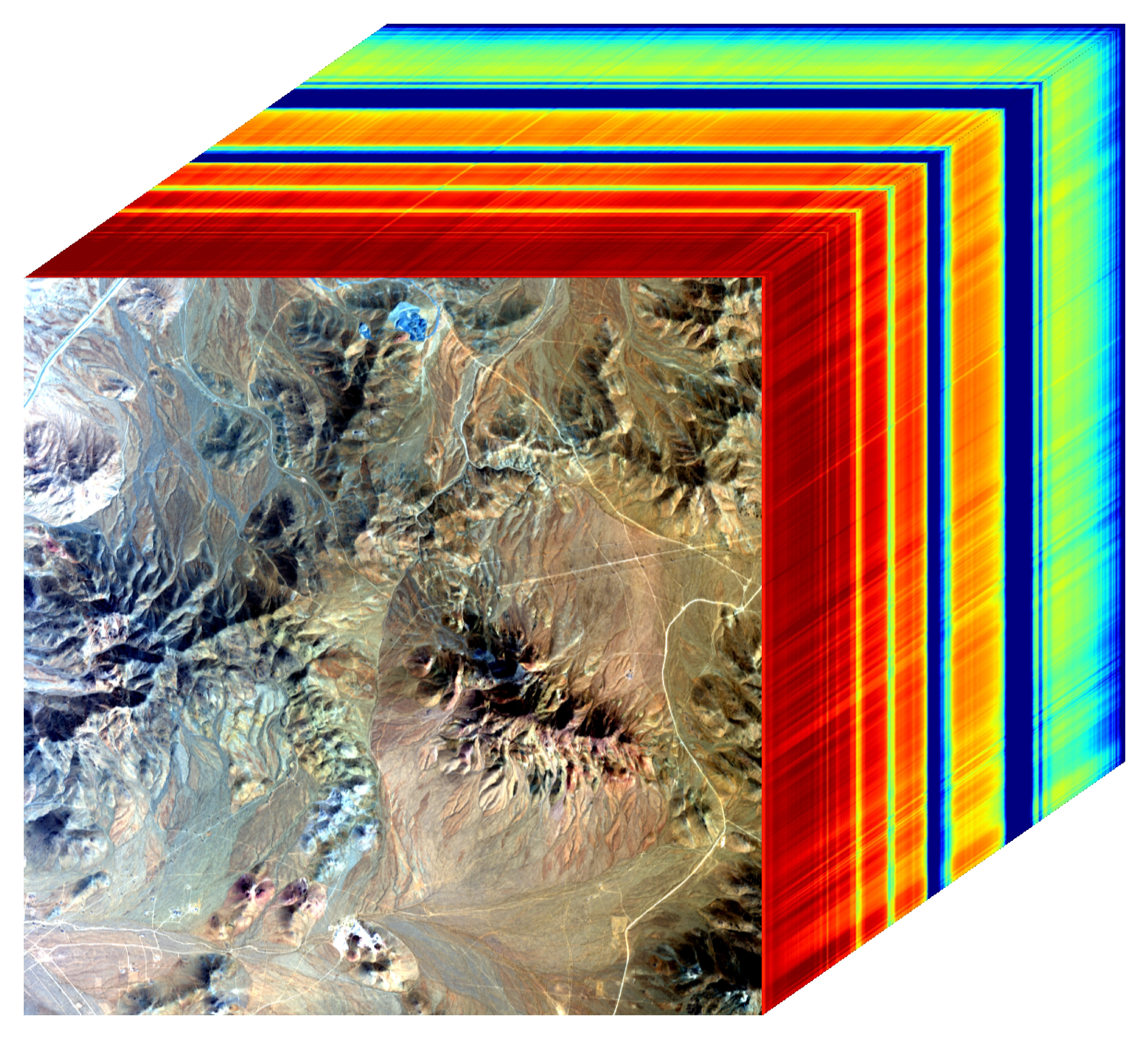
Three-dimensional image cubes illustrate the volume of data captured by NASA imaging spectrometers. The front face shows an aerial view of the Mojave Desert. The colorful side panels reveal what no eye or camera can detect: the spectral fingerprints of minerals present in every pixel.
NASA/JPL-Caltech
Next-generation mineral mapping
The sensor that detected the topaz deposit on public land near Barstow, California, was built at JPL. Called AVIRIS, short for Airborne Visible Infrared Imaging Spectrometer, it analyzes reflected sunlight and can be used to identify chemicals and minerals by their unique spectral fingerprint. The technology was pioneered in the early 1980s by a team that included Green, and space-hardened versions have explored the Moon, Mars, and other rocky bodies in the solar system in the decades since.
While its cousins study distant worlds aboard spacecraft, the AVIRIS line of sensors is advancing Earth science from aircraft. The latest model, AVIRIS-5, recently took to the skies for the first time as part of the NASA-USGS Geologic Earth Mapping Experiment (GEMx). The goal of GEMx is to identify sources of critical minerals across the American West, including in the waste rock of active and legacy mines. It is led by the USGS as part of its larger, nationwide initiative.
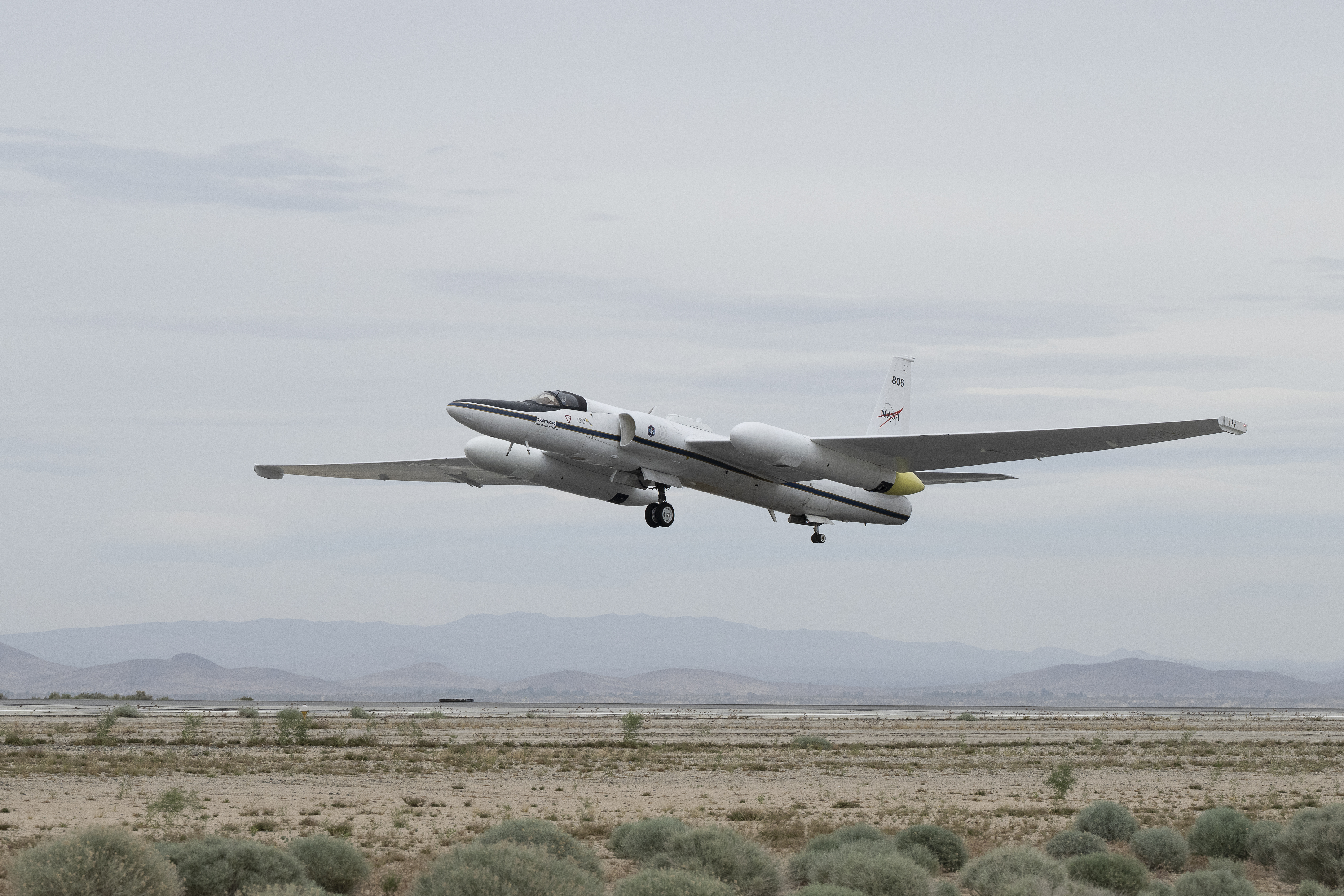
Carrying next-generation sensors, a high-altitude NASA ER-2 aircraft takes off from the agency’s Armstrong Flight Research Center in Edwards, California, on March 31, 2026, to support the GEMx mineral mapping campaign.
NASA/Carla Thomas
Since 2023, GEMx flights have covered more than 386,000 square miles (1 million square kilometers) of American soil, including most of California.
Ground-truthing the sensor data can entail hot field work, scrambling over steep crags to uncover samples for lab analysis. While testing has confirmed the topaz discovery, determining if the Mojave site overlies a porphyry copper deposit will require intensive investigation using ground-penetrating equipment. But the AVIRIS finding shows how advanced NASA airborne sensing can help lead geologists to the metaphorical needle in a haystack, even in heavily explored Southern California.
“People have been prospecting this area for generations,” said Erik Tharalson, a USGS geologist. “But there’s a lot more to discover.”
High flyer
From the beginning, the GEMx mineral mapping campaign has been enabled by one of the highest-flying aircraft in NASA’s fleet: the ER‑2. It deployed on March 31 from NASA’s Armstrong Flight Research Center in Edwards, California, to Colorado Springs Airport in Colorado.
“We deployed to Colorado Springs to maximize flight time for data collection needed in Colorado, Utah, New Mexico, Arizona, and Texas,” said John McGrath, ER‑2 project manager at NASA Armstrong.
By the conclusion of this deployment on June 5, the aircraft had completed 26 flights totaling more than 125 hours. Soaring at about 65,000 feet, the ER-2 can fly at high altitudes that allow it to collect broad‑area, high‑resolution spectral measurements in a single pass, supporting researchers studying mineral composition and surface processes.
In 2025, the aircraft flew 36 science missions, collecting more than 7 billion measurements over 200 flight hours. The data has contributed to the largest airborne surface mineralogy dataset gathered in a single NASA-USGS campaign.
The GEMx survey is led and funded by the USGS Earth Mapping Resources Initiative. Earth MRI is modernizing mapping the nation’s surface and subsurface to find new, critical, and other minerals. It is a partnership effort with 45 state geological surveys, federal agencies, private industry, tribes, universities, and others. The initiative will capitalize on both the technology developed by NASA for spectroscopic imaging, as well as the USGS expertise in analyzing the datasets, conducting field work, and deriving critical mineral information from them.
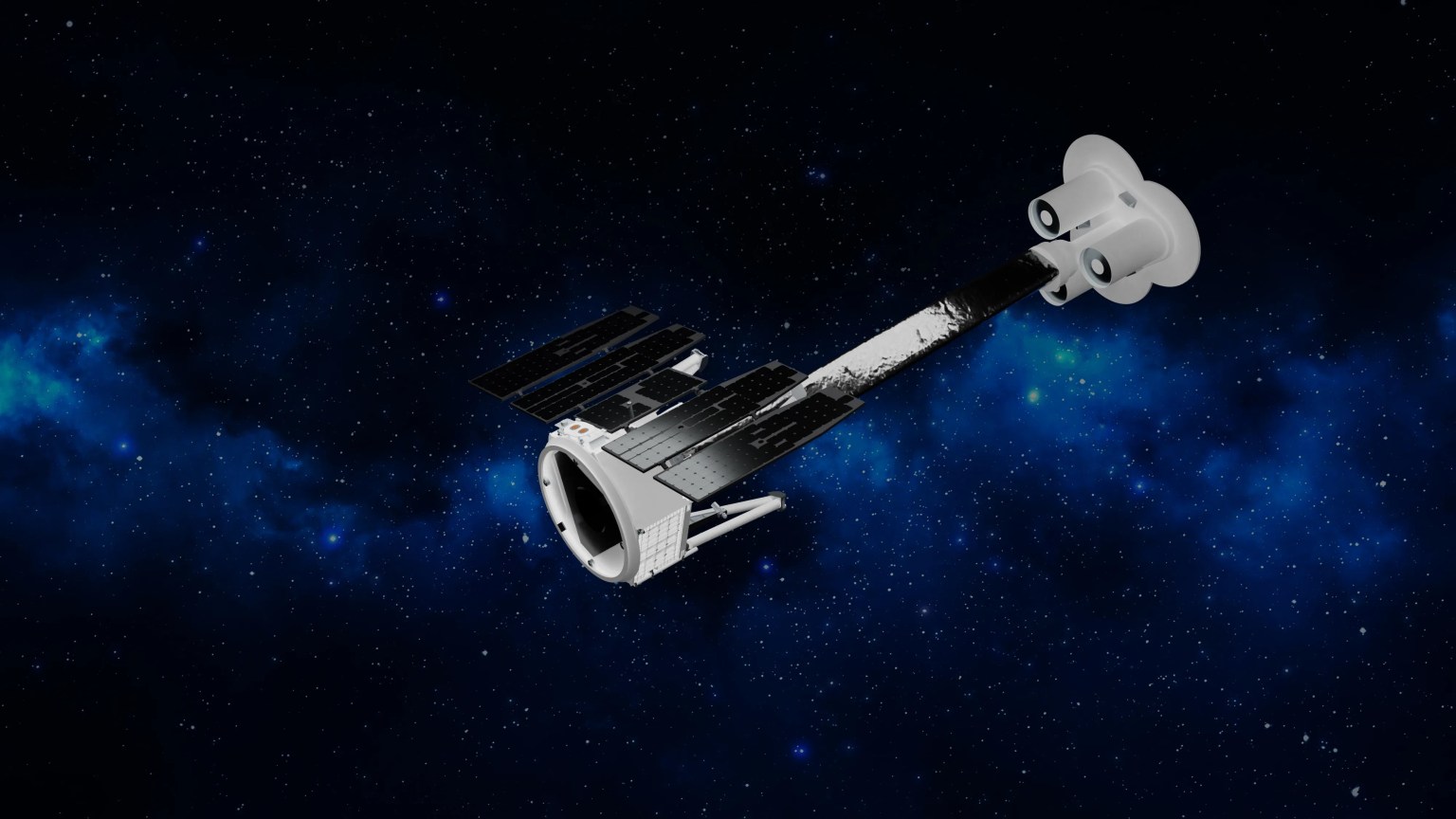
Katalyst Space’s LINK robotic servicing satellite awaits encapsulation inside a Northrop Grumman Pegasus XL on June 8, 2026, at NASA’s Wallops Flight Facility in Virginia. The rocket will carry LINK to space for an attempted orbital boost of NASA’s Neil Gehrels Swift Observatory.
Credit: NASA/Ron Beard
NASA will host an audio-only media teleconference at 11 a.m. EDT, Wednesday, June 17, to preview the Katalyst Space mission to boost the orbit of NASA’s Neil Gehrels Swift Observatory.
Katalyst’s robotic servicing spacecraft, called LINK, will attempt to rendezvous with Swift and raise its altitude, extending its science mission lifespan and advancing a key capability for the future of space exploration. The LINK spacecraft will launch on Northrop Grumman’s Pegasus XL rocket later this month from Kwajalein Atoll in the Marshall Islands.
Media interested in participating by phone must RSVP no later than two hours before the start of the call to Amy Barra at: amy.l.barra@nasa.gov. NASA’s media accreditation policy is available online.
Audio of the media teleconference will stream on the agency’s website at:
The Swift mission, which launched in 2004, leads NASA’s fleet of telescopes in studying changes in the high-energy universe, like gamma-ray bursts, which are the most powerful explosions in the cosmos. When a rapid, sudden event takes place in the sky, Swift serves as a “dispatcher,” providing critical information that allows other “first responder” missions to follow up to learn more about how the universe works.
After 21 years, Swift’s low Earth orbit has begun to rapidly decay because of increased solar activity. Rather than allowing the observatory to re-enter Earth’s atmosphere, as many missions do at the end of their lifetimes, NASA is using this opportunity to advance U.S. spacecraft servicing technology. In September 2025, NASA awarded a contract to Katalyst to mount a robotic servicing mission for Swift in less than a year. The mission will use LINK to rendezvous with Swift and boost it to a higher altitude, demonstrating a key capability for the future of space exploration. The mission is targeted for launch in June from Kwajalein Atoll, Marshall Islands.
Learn more about the mission to boost Swift’s orbit at:
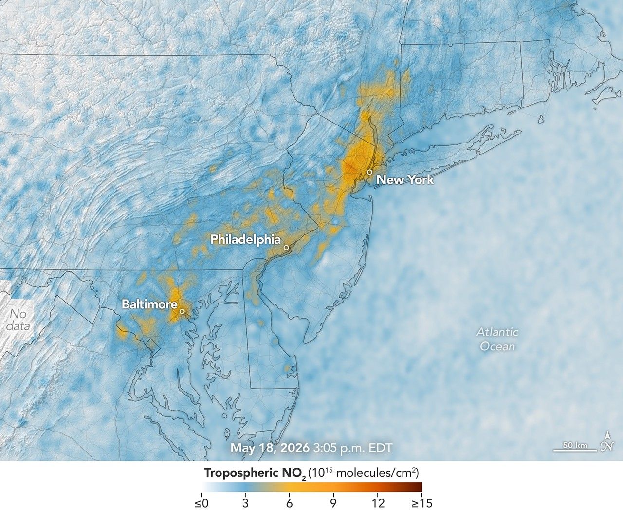
TEMPO detected high concentrations of nitrogen dioxide during the morning commute at 7:05 a.m. local time on May 18, 2026 (left), along the New York-Washington corridor. The instrument detected lower levels of the gas at 3:05 p.m. (right), after chemical reactions involving nitrogen dioxide had contributed to elevated ozone concentrations in the afternoon.
NASA Earth Observatory/Michala Garrison
7:05 am
3:05 pm
TEMPO detected high concentrations of nitrogen dioxide during the morning commute at 7:05 a.m. local time on May 18, 2026 (left), along the New York-Washington corridor.The instrument detected lower levels of the gas at 3:05 p.m. EDT (right), after chemical reactions involving nitrogen dioxide had contributed to elevated ozone concentrations in the afternoon. NASA Earth Observatory images by Michala Garrison.
More than 35 million people live along the New York–Washington corridor and breathe the region’s air. While air quality has improved significantly in recent decades, outbreaks of ground-level ozone remain common, particularly in the warm summer months, when the chemical reactions that produce the pollutant accelerate and stagnant air allows ozone to accumulate.
A reminder of this seasonal phenomenon came earlier than usual in 2026, when a mid-May heat wave prompted the New York State Department of Health and the New York Department of Environmental Conservation to issue a health advisory on May 17 over concerns about ozone. The code orange advisory warned young people, older adults, and those working or exercising outdoors to limit activity due to ozone’s respiratory and cardiovascular health impacts.
As expected, ground-based air-quality sensors operated by state and federal agencies showed ozone reaching unhealthy levels for sensitive groups on May 18, something that typically happens several times per year. Meanwhile, NASA’s TEMPO (Tropospheric Emissions: Monitoring of Pollution) instrument observed the event from geostationary orbit 22,000 miles (35,000 kilometers) above the equator, a unique vantage point that allows the sensor to collect frequent observations of air pollution.
TEMPO detects nitrogen dioxide (NO2), a gas emitted by burning fuels, particularly by motor vehicles, that contributes to ozone formation. “There’s often a clear and interesting pattern in TEMPO’s nitrogen dioxide data during ozone alert days,” said Hazem Mahmoud, an atmospheric scientist at NASA’s Atmospheric Science Data Center at Langley Research Center. “We see high concentrations of nitrogen dioxide during the early morning commute that drop off sharply in the late afternoon as ozone increases.”
The decline occurs as sunlight fuels photochemical reactions involving nitrogen dioxide, volatile organic compounds, and oxygen that lead to ozone formation. By late afternoon, these reactions deplete much of the available nitrogen dioxide, slowing ozone production until the cycle begins again the next day.
The pair of images above underscores the pattern. The image on the left was acquired at 7:05 a.m. local time when nitrogen dioxide concentrations were high during the morning commute. By 3:05 p.m. (right), most of the nitrogen dioxide had declined substantially, and surface ozone levels were elevated (below). Meanwhile, afternoon sea breezes appear to have transported the remaining nitrogen dioxide slightly to the west. Note that the data shown is provisional, and processing methods are still being refined.
Sensors on earlier polar-orbiting satellites, such as OMI (Ozone Monitoring Instrument) and TROPOMI (Tropospheric Monitoring Instrument), sampled nitrogen dioxide over New York once per day. After its launch in 2023, TEMPO began providing data every hour, allowing researchers to track the evolution and dispersion of air pollution at much finer time scales.
“TEMPO is helping fill data gaps between ground stations and allowing us to ask new questions,” Mahmoud said. The mission provides data that can improve not only air quality forecasts during crisis situations, such as wildfires, but also the atmospheric models used to forecast the daily rhythms of urban pollution. Such models help researchers understand how natural factors such as winds, humidity levels, and air temperatures influence pollution plumes over the course of a day.
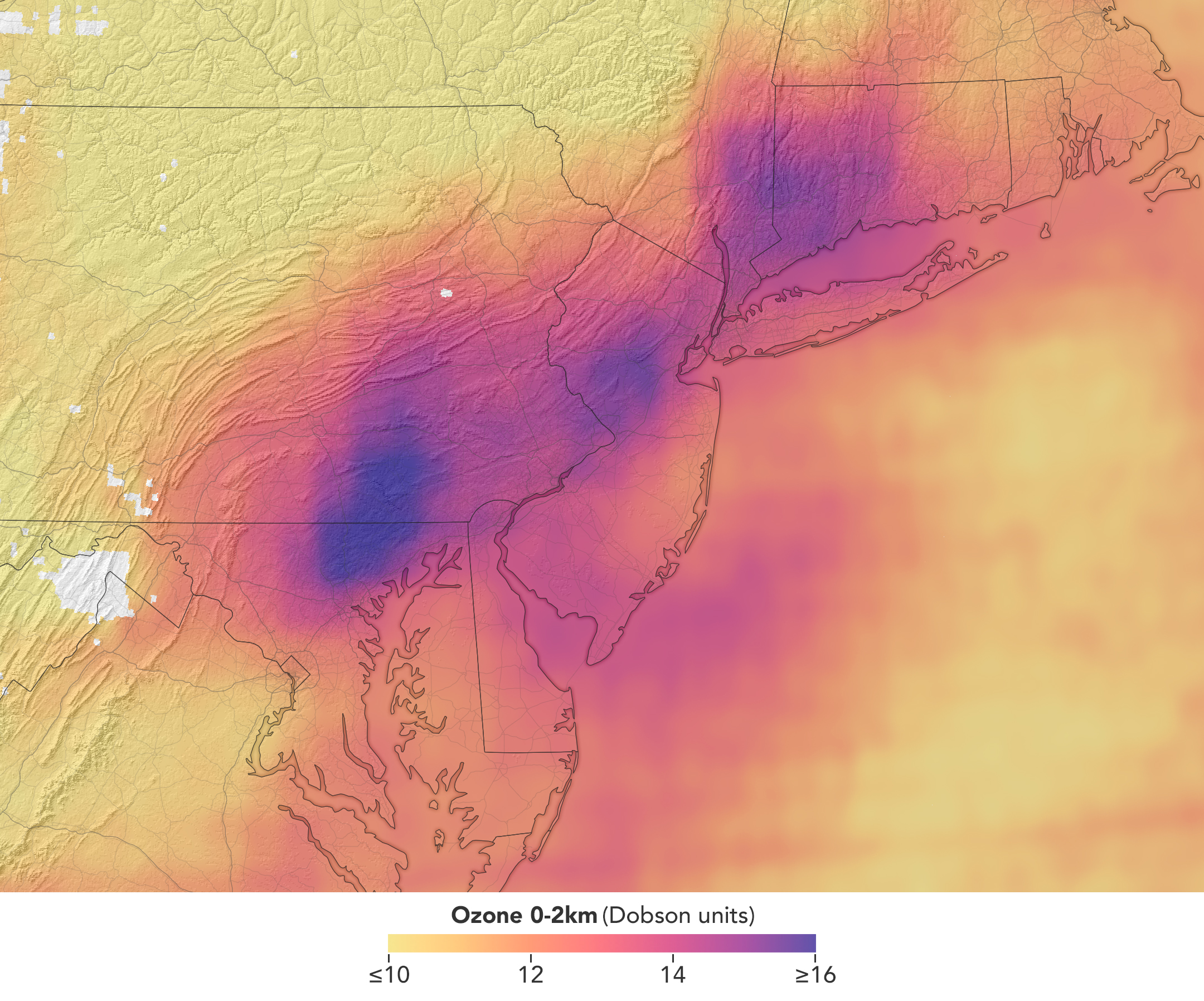
TEMPO detected elevated ozone concentrations in an area extending from New York City to Washington, D.C., at 5:05 p.m. on May 18, 2026.
NASA Earth Observatory/Michala Garrison
TEMPO also detects ozone directly, but determining how much of that ozone is near the surface versus higher in the atmosphere can be challenging. Most of Earth’s ozone resides in the stratosphere, well above the troposphere, where people live and breathe. At times, however, stratospheric ozone can be transported downward into the troposphere. During events known as stratospheric intrusions, it can even descend far enough to affect air quality at the surface and add to the ozone produced at ground level.
By combining TEMPO observations with other sources of information, researchers are studying the processes that influence the distribution of ozone vertically in the atmosphere. On May 18, NASA’s ground-based tropospheric lidar network (TOLNet) in New York City recorded high concentrations of ozone near the surface, indicating that TEMPO was detecting mostly surface-level ozone associated with urban emissions and not ozone aloft, said Mahmoud.
However, on May 19, the same sensor observed a layer of ozone descending from above 5 kilometers (3 miles), he added, a clue that some of the ozone TEMPO detected that day may have originated in the stratosphere. “This is the type of information that leads to better air quality forecast models and more accurate alerts,” Mahmoud said. “Alerts can affect tens of millions of people and lead to disruptions in school, sports, and other activities, so it’s essential that they be as accurate as possible.”
On June 6, New York authorities issued another health advisory for ozone. People interested in following the event can access daily near-real-time TEMPO observations of ozone, nitrogen dioxide, and other gases on NASA’s Worldview browser, on an interactive Harvard & Smithsonian Center for Astrophysics browsing tool, and on NASA’s Earthdata portal.
NASA Earth Observatory images by Michala Garrison, using TEMPO data from NASA Earthdata.Story by Adam Voiland.


